Category:1890s maps of Denver, Colorado
Jump to navigation
Jump to search
Subcategories
This category has the following 3 subcategories, out of 3 total.
Media in category "1890s maps of Denver, Colorado"
The following 19 files are in this category, out of 19 total.
-
 Map of Driving Park Place - DPLA - 1115c35021ba599157561535ac63f9f5.jpg 9,000 × 5,755; 5.9 MB
-
-

-

-
-

-

-
 Denver showing street railway lines - DPLA - 1258fd2accfb042d4c181fef641cd0c3.jpg 6,426 × 5,634; 4.97 MB
-
 Denver showing street railway lines - DPLA - ebcfbe9f020375b14e8807fa02e661a6.jpg 8,999 × 7,451; 15.84 MB
-
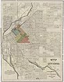
 Map of University Park (Denver, Colo.) - DPLA - eeab06484f82b8ae3e7e99da8d9e39f5.jpg 8,999 × 5,855; 6.33 MB
-
 Map of University Park Denver, Colorado - DPLA - 91c0c7cb8040612ad571f4eda7a644b7.jpg 9,000 × 5,816; 6.64 MB
-
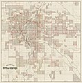
 Map showing business section, city of Denver - DPLA - e12896a7ecf559f47116391216b94f78.jpg 8,999 × 8,198; 18.8 MB
-
 Rollandet's guide map & street index to Denver - DPLA - aec322598198c8d3b7dd0a496ad18cfa.jpg 9,000 × 8,859; 11.59 MB
-
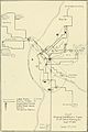 The street railway review (1891) (14574068790).jpg 1,338 × 2,006; 220 KB
-
 Map of Denver - DPLA - 3b96e4accbab69e5f20d0c383912f32b.jpg 9,000 × 6,276; 8.53 MB
-
 Park and boulevard system of Denver - DPLA - 55be24033aec0c9f43141a2e81e946c8.jpg 6,668 × 7,200; 4.59 MB
-

-
 Guide map to the city of Denver - DPLA - e7e99c3f610deb69d168d76bedbd9b29.jpg 9,000 × 8,971; 11.48 MB
-
 Pocket map of the city of Denver - DPLA - 137cf406637946dd8b3e72ab8352085c.jpg 9,000 × 8,413; 15.86 MB


_-_DPLA_-_eeab06484f82b8ae3e7e99da8d9e39f5.jpg)


_(14574068790).jpg)


