Category:1890 maps of Georgia (U.S. state)
Jump to navigation
Jump to search
States of the United States: California · Connecticut · Florida · Georgia · Idaho · Illinois · Iowa · Kansas · Kentucky · Louisiana · Maine · Maryland · Massachusetts · Michigan · Minnesota · Mississippi · Missouri · Montana · Nevada · New Hampshire · New Jersey · New Mexico · New York · North Carolina · North Dakota · Ohio · Oklahoma · Oregon · Pennsylvania · Rhode Island · South Carolina · South Dakota · Texas · Utah · Vermont · Virginia · Washington · West Virginia · Wisconsin · Wyoming – Washington, D.C.
| ← 1890 1892 1893 1895 1896 1897 1898 1899 → |
Subcategories
This category has the following 6 subcategories, out of 6 total.
S
Media in category "1890 maps of Georgia (U.S. state)"
The following 45 files are in this category, out of 45 total.
-
 Abraham Lincoln - a history (1890) (14594147450).jpg 1,640 × 1,684; 820 KB
-
 Abraham Lincoln - a history (1890) (14594152189).jpg 2,304 × 1,620; 1.32 MB
-
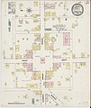
 Sanborn Fire Insurance Map from Camilla, Mitchell County, Georgia. LOC sanborn01396 002.jpg 6,450 × 7,650; 2.99 MB
-
 Sanborn Fire Insurance Map from Camilla, Mitchell County, Georgia. LOC sanborn01396 002.tif 6,450 × 7,650; 141.17 MB
-
-
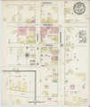
 Sanborn Fire Insurance Map from Carrollton, Carroll County, Georgia. LOC sanborn01398 002.tif 6,450 × 7,650; 141.17 MB
-
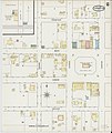
 Sanborn Fire Insurance Map from Conyers, Rockdale County, Georgia. LOC sanborn01409 002.jpg 6,450 × 7,650; 3.66 MB
-
 Sanborn Fire Insurance Map from Conyers, Rockdale County, Georgia. LOC sanborn01409 002.tif 6,450 × 7,650; 141.17 MB
-

-
 Sanborn Fire Insurance Map from Cuthbert, Randolph County, Georgia. LOC sanborn01414 002.tif 6,450 × 7,650; 141.17 MB
-
 Sanborn Fire Insurance Map from Darien, Mcintosh County, Georgia. LOC sanborn01417 002.jpg 6,450 × 7,650; 3.54 MB
-
 Sanborn Fire Insurance Map from Darien, Mcintosh County, Georgia. LOC sanborn01417 002.tif 6,450 × 7,650; 141.17 MB
-
 Sanborn Fire Insurance Map from Eatonton, Putnam County, Georgia. LOC sanborn01428 002.jpg 6,450 × 7,650; 3.04 MB
-
 Sanborn Fire Insurance Map from Eatonton, Putnam County, Georgia. LOC sanborn01428 002.tif 6,450 × 7,650; 141.17 MB
-
 Sanborn Fire Insurance Map from Fort Gaines, Clay County, Georgia. LOC sanborn01437 002.jpg 6,450 × 7,650; 3.57 MB
-
 Sanborn Fire Insurance Map from Fort Gaines, Clay County, Georgia. LOC sanborn01437 002.tif 6,450 × 7,650; 141.17 MB
-

-
 Sanborn Fire Insurance Map from Fort Valley, Peach County, Georgia. LOC sanborn01438 001.tif 6,450 × 7,650; 141.17 MB
-
 Sanborn Fire Insurance Map from Greensboro, Greene County, Georgia. LOC sanborn01443 002.jpg 6,450 × 7,650; 3.01 MB
-
 Sanborn Fire Insurance Map from Greensboro, Greene County, Georgia. LOC sanborn01443 002.tif 6,450 × 7,650; 141.17 MB
-
 Sanborn Fire Insurance Map from Hampton, Henry County, Georgia. LOC sanborn01446 001.jpg 6,450 × 7,650; 3.41 MB
-
 Sanborn Fire Insurance Map from Hampton, Henry County, Georgia. LOC sanborn01446 001.tif 6,450 × 7,650; 141.17 MB
-
 Sanborn Fire Insurance Map from Jonesboro, Clayton County, Georgia. LOC sanborn01456 001.jpg 6,450 × 7,650; 3.19 MB
-
 Sanborn Fire Insurance Map from Jonesboro, Clayton County, Georgia. LOC sanborn01456 001.tif 6,450 × 7,650; 141.17 MB
-

-
 Sanborn Fire Insurance Map from Montezuma, Macon County, Georgia. LOC sanborn01478 002.tif 6,450 × 7,650; 141.17 MB
-
 Sanborn Fire Insurance Map from Palmetto, Fulton County, Georgia. LOC sanborn01485 002.jpg 6,450 × 7,650; 2.92 MB
-
 Sanborn Fire Insurance Map from Thomaston, Upson County, Georgia. LOC sanborn01513 003.jpg 6,450 × 7,650; 3.29 MB
-
 Sanborn Fire Insurance Map from Thomaston, Upson County, Georgia. LOC sanborn01513 003.tif 6,450 × 7,650; 141.17 MB
-
 Sanborn Fire Insurance Map from Warrenton, Warren County, Georgia. LOC sanborn01526 002.jpg 6,450 × 7,650; 2.96 MB
-
 Sanborn Fire Insurance Map from Warrenton, Warren County, Georgia. LOC sanborn01526 002.tif 6,450 × 7,650; 141.17 MB
-
 Sanborn Fire Insurance Map from Washington, Wilkes County, Georgia. LOC sanborn01527 002-1.tif 6,450 × 7,650; 141.17 MB
-

-
 Sanborn Fire Insurance Map from Washington, Wilkes County, Georgia. LOC sanborn01527 002-2.tif 6,450 × 7,650; 141.17 MB
-

-
 Sanborn Fire Insurance Map from Waynesboro, Burke County, Georgia. LOC sanborn01529 002-1.tif 6,450 × 7,650; 141.17 MB
-

-
 Sanborn Fire Insurance Map from Waynesboro, Burke County, Georgia. LOC sanborn01529 002-2.tif 6,450 × 7,650; 141.17 MB
-

-
 Sanborn Fire Insurance Map from West Point, Troup County, Georgia. LOC sanborn01530 002-1.tif 6,450 × 7,650; 141.17 MB
-

-
 Sanborn Fire Insurance Map from Thomaston, Upson County, Georgia. LOC sanborn01513 002-1.jpg 6,450 × 7,650; 3.67 MB
-
 Sanborn Fire Insurance Map from Thomaston, Upson County, Georgia. LOC sanborn01513 002-1.tif 6,450 × 7,650; 141.17 MB
-
 Sanborn Fire Insurance Map from Thomaston, Upson County, Georgia. LOC sanborn01513 002-2.jpg 6,450 × 7,650; 3.31 MB
-
 Sanborn Fire Insurance Map from Thomaston, Upson County, Georgia. LOC sanborn01513 002-2.tif 6,450 × 7,650; 141.17 MB
_(14594147450).jpg)
_(14594152189).jpg)


