Category:1884 U.S. presidential election maps, county subdivisions
Jump to navigation
Jump to search
Media in category "1884 U.S. presidential election maps, county subdivisions"
The following 9 files are in this category, out of 9 total.
-
 PresidentialCounty1884Colorbrewer.gif 2,800 × 1,700; 207 KB
-
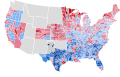 1884 United States presidential election results map by county.svg 555 × 352; 1.16 MB
-
 DemocraticPresidentialCounty1884.gif 2,800 × 2,200; 242 KB
-
 DemocraticPresidentialCounty1884Colorbrewer.gif 2,800 × 1,700; 183 KB
-
 OtherPresidentialCounty1884.gif 2,800 × 2,200; 193 KB
-
 OtherPresidentialCounty1884Colorbrewer.gif 2,800 × 1,700; 177 KB
-
 PresidentialCounty1884.gif 2,800 × 2,200; 267 KB
-
 RepublicanPresidentialCounty1884.gif 2,800 × 2,200; 239 KB
-
 RepublicanPresidentialCounty1884Colorbrewer.gif 2,800 × 1,700; 178 KB


