Category:1880s maps of Annam (protectorate)
Jump to navigation
Jump to search
Subcategories
This category has only the following subcategory.
Media in category "1880s maps of Annam (protectorate)"
The following 15 files are in this category, out of 15 total.
-

-

-
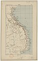
 Admiralty Chart No 1342 Fan Rang Bay to Tong King Gulf, Published 1882.jpg 10,912 × 16,240; 56.34 MB
-
 Karte von Tongking.png 6,583 × 8,529; 81.63 MB
-
 Tong-King - gravé par J. Geisendörfer - btv1b8439070b.jpg 7,255 × 9,082; 7.02 MB
-
 Tong-King gravé par J. Geisendörfer.jpg 7,255 × 9,082; 7.25 MB
-
 Wyld's Map of Tong-King and Annam - btv1b53023137m.jpg 6,731 × 8,868; 9.03 MB
-
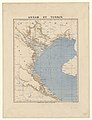
 Annam et Tonkin (Nouvelle édition) - btv1b53022705d.jpg 5,795 × 7,337; 6.04 MB
-
 Annam et Tonkin - btv1b530212322.jpg 6,861 × 8,933; 8.15 MB
-

-

-

-
 Annam - btv1b8439722p.jpg 4,256 × 6,727; 3.45 MB
-

-

.jpg)
.jpg)


_-_btv1b53022705d.jpg)

_-_dress%C3%A9_d%27apr%C3%A8s_les_itin%C3%A9raires_des_officiers,_les_cartes_annamites_et_les_travaux_du_P._Pinabel,_Missionnaire_-_btv1b53169724q_(1_of_3).jpg)
_-_dress%C3%A9_d%27apr%C3%A8s_les_itin%C3%A9raires_des_officiers,_les_cartes_annamites_et_les_travaux_du_P._Pinabel,_Missionnaire_-_btv1b53169724q_(2_of_3).jpg)
_-_dress%C3%A9_d%27apr%C3%A8s_les_itin%C3%A9raires_des_officiers,_les_cartes_annamites_et_les_travaux_du_P._Pinabel,_Missionnaire_-_btv1b53169724q_(3_of_3).jpg)

_-_dress%C3%A9_d%27apr%C3%A8s_les_itin%C3%A9raires_des_officiers,_les_cartes_annamites_et_les_travaux_du_P._Pinabel,_Missionnaire_-_btv1b531580301_(1_of_2).jpg)
_-_dress%C3%A9_d%27apr%C3%A8s_les_itin%C3%A9raires_des_officiers,_les_cartes_annamites_et_les_travaux_du_P._Pinabel,_Missionnaire_-_btv1b531580301_(2_of_2).jpg)