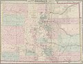
Category:1878 maps of Colorado
Jump to navigation
Jump to search
States of the United States: California · Colorado · Connecticut · Illinois · Maryland · Michigan · New York · Pennsylvania · Texas
| 1878 |
Media in category "1878 maps of Colorado"
The following 10 files are in this category, out of 10 total.
-
 Colorado - DPLA - 1f6ef8b87249acfc504071cee110add1.jpg 8,004 × 6,596; 9.14 MB
-
-

-
 Colton's new sectional map of the State of Colorado. LOC 2006627671.jpg 12,293 × 9,131; 13.26 MB
-
 Colton's new sectional map of the State of Colorado. LOC 2006627671.tif 12,293 × 9,131; 321.14 MB
-
 EB9 Colorado.jpg 2,501 × 1,820; 2.06 MB
-
-
 Parts of south western Colorado, atlas sheet 61A - DPLA - 456458d38118c6a18e317437e519392e.jpg 8,000 × 7,394; 12.77 MB
-
 Post route map of the State of Colorado - DPLA - dead92060869f2e6e65b7b43947a542b.jpg 9,000 × 6,297; 5.77 MB
-


