Category:1876 maps of Philadelphia
Jump to navigation
Jump to search
Media in category "1876 maps of Philadelphia"
The following 23 files are in this category, out of 23 total.
-
 10 of 'Philadelphia and its environs, illustrated' (11113141733).jpg 3,749 × 2,693; 2.54 MB
-

-

-

-
-

-
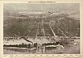
 Birds-eye view of the city of Philadelphia (2674257909).jpg 2,000 × 1,378; 2.56 MB
-
-
 Map of the water frontage of the port of Philadelphia (NYPL b10554778-5247816).tiff 7,760 × 10,328, 2 pages; 229.57 MB
-
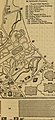
 Map of the centennial grounds and vicinity, Philadelphia (NYPL b13844877-5247818).tiff 7,760 × 10,328, 2 pages; 229.57 MB
-

-

-

-

-
-

-

-

-
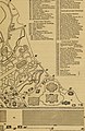
 Part of Thirteeth Ward Philadelphia.jpg 1,000 × 672; 153 KB
-
 Philadelphia and its environs (1876) (14790883283).jpg 2,259 × 3,452; 1.21 MB
-

-
 Treat's illustrated New York, Philadelphia and surroundings (1876) (14760098911).jpg 2,164 × 3,352; 1.21 MB
-
 Treat's illustrated New York, Philadelphia and surroundings (1876) (14763280965).jpg 2,282 × 3,956; 1.39 MB
.jpg)
.jpg)
%27_(11112108966).jpg)


.jpg)

_(14590154629).jpg)
_(14590299409).jpg)
_(14753909806).jpg)
_(14773808691).jpg)
_(14776473572).jpg)
_(14776565102).jpg)
_(14776601702).jpg)
_(14796817433).jpg)

_(14790883283).jpg)

_(14760098911).jpg)
_(14763280965).jpg)