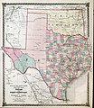
Category:1875 maps of Texas
Jump to navigation
Jump to search
States of the United States: California · Connecticut · Illinois · Iowa · Michigan · New Jersey · New York · Ohio · Oklahoma · Oregon · Pennsylvania · Tennessee · Texas · Utah · Virginia · Wyoming
| 1871 1872 1874 1875 1876 1877 1878 1879 → |
Media in category "1875 maps of Texas"
The following 6 files are in this category, out of 6 total.
-
County map of Texas, and Indian Territory. LOC 2006629766.jpg 3,881 × 4,505; 3.07 MB
-
County map of Texas, and Indian Territory. LOC 2006629766.tif 3,881 × 4,505; 50.02 MB
-
Warner & Beers County Map of Texas and Indian Territory 1875 UTA.jpg 4,661 × 5,368; 11.21 MB
-
Map of Llano County - showing geology, mineral localities, topography, etc. LOC 2009583520.tif 8,217 × 6,300; 148.11 MB
-
Roessler New Map of Texas 1875 UTA.jpg 4,993 × 4,632; 10.39 MB


