
Category:1870s maps of Hamburg
Federal states of Germany:
Media in category "1870s maps of Hamburg"
The following 11 files are in this category, out of 11 total.
-
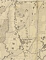 Langenhorn 1871.JPG 735 × 949; 186 KB
-
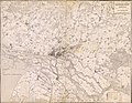 PPN612044777 Das Hamburger Gebiet und dessen Umgegend (1871).jpg 10,170 × 7,883; 18.81 MB
-
 PPN612044777 Das Hamburger Gebiet und dessen Umgegend (1871).tif 10,562 × 7,961; 45.68 MB
-
 PPN61229675X Karte der Vogtei Eppendorf (1873).jpg 5,785 × 6,881; 5.06 MB
-
 PPN61229675X Karte der Vogtei Eppendorf (1873).tif 5,948 × 7,372; 12.59 MB
-
 PPN611970872 Hoheluft zwischen Heußweg, Lockstedter Weg und Langenfelder Damm (1875).jpg 8,878 × 7,141; 8.81 MB
-
 PPN611970872 Hoheluft zwischen Heußweg, Lockstedter Weg und Langenfelder Damm (1875).tif 10,250 × 7,610; 21.26 MB
-
 PPN735422826 Karte der Stadt Bergedorf (1996 Reprod.).jpg 13,966 × 9,332; 21.34 MB
-

-

-
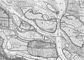 Altenwerder-1878.jpg 2,171 × 1,549; 1.66 MB

.jpg)
.jpg)
.jpg)
.jpg)
.jpg)
