Category:1866 in Indre-et-Loire
Jump to navigation
Jump to search
Departments of Metropolitan France: Alpes-Maritimes [06] · Calvados [14] · Finistère [29] · Gard [30] · Haute-Garonne [31] · Gers [32] · Indre-et-Loire [37] · Marne [51] · Morbihan [56] · Moselle [57] · Puy-de-Dôme [63] · Pyrénées-Orientales [66] · Bas-Rhin [67] · Haut-Rhin [68] · Paris [75]
Overseas departments and regions: Martinique [972] · French Guiana [973]
Overseas departments and regions: Martinique [972] · French Guiana [973]
Media in category "1866 in Indre-et-Loire"
The following 12 files are in this category, out of 12 total.
-
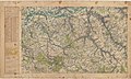
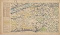 Carte d'État-major de la France, Feuille Blois S.O.jpg 23,409 × 13,908; 91.64 MB
-
 Carte d'État-major de la France, Feuille Loches N.E.jpg 23,787 × 14,183; 95.47 MB
-
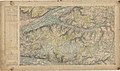 Carte d'État-major de la France, Feuille Loches N.O.jpg 23,787 × 14,172; 101.58 MB
-
 Carte d'État-major de la France, Feuille Loches S.E.jpg 23,787 × 14,181; 102.12 MB
-
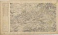
 Carte d'État-major de la France, Feuille Loches S.O.jpg 23,787 × 14,183; 103.07 MB
-
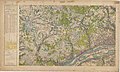
 Carte d'État-major de la France, Feuille Tours N.E.jpg 23,480 × 13,834; 96.09 MB
-
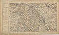
 Carte d'État-major de la France, Feuille Tours N.O.jpg 23,480 × 14,012; 102.22 MB
-
 Carte d'État-major de la France, Feuille Tours S.E.jpg 22,843 × 13,788; 91.85 MB
-
 Carte d'État-major de la France, Feuille Tours S.O.jpg 23,409 × 14,029; 100.05 MB
-
 Carte d'État-major de la France, Feuille Valencay N.E.jpg 23,764 × 13,960; 104.05 MB
-
 Carte d'État-major de la France, Feuille Valencay N.O.jpg 23,764 × 14,037; 104.67 MB
-
 Carte d'État-major de la France, Feuille Valencay S.O.jpg 23,764 × 14,381; 102.63 MB


