Category:1860s maps of Japan
Jump to navigation
Jump to search
Subcategories
This category has the following 6 subcategories, out of 6 total.
- 1861 maps of Japan (1 F)
- 1862 maps of Japan (1 F)
Media in category "1860s maps of Japan"
The following 10 files are in this category, out of 10 total.
-
 Chassiron nagasaki.png 1,500 × 1,195; 3.58 MB
-
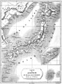
 Newly engraved map of Great Japan (15136421840).jpg 2,500 × 1,815; 1.74 MB
-
 Pocket map of Yamashiro Province (15319978301).jpg 2,500 × 1,782; 2.28 MB
-

-
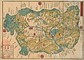
 Map of nine counties of Shimotsuke (15206523770).jpg 2,500 × 1,583; 1.81 MB
-
 Hizen Nagasaki no Du - btv1b84592213 (1 of 2).jpg 10,896 × 7,426; 13.28 MB
-
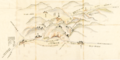
 Le Tour du monde-01-p100.jpg 1,219 × 810; 325 KB
-
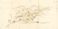
 Le Tour du monde-01-p164.jpg 822 × 1,108; 278 KB
-
 敦賀・琵琶湖間運河計画図(1867年) (cropped).png 1,432 × 719; 1.36 MB
-
 敦賀・琵琶湖間運河計画図(1867年).png 1,703 × 868; 1.77 MB

.jpg)
.jpg)
.jpg)


.png)

.jpg)
.jpg)