Category:1860 U.S. presidential election maps, county subdivisions
Jump to navigation
Jump to search
Media in category "1860 U.S. presidential election maps, county subdivisions"
The following 24 files are in this category, out of 24 total.
-
 CartogramFusionPresidentialCounty1860.png 2,800 × 2,200; 193 KB
-
 CartogramNorthernDemocraticPresidentialCounty1860.png 2,800 × 2,200; 224 KB
-
 CartogramPresidentialCounty1860.png 2,800 × 2,200; 242 KB
-
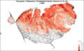
 CartogramRepublicanPresidentialCounty1860.png 2,800 × 2,200; 214 KB
-
 CartogramSouthernDemocraticPresidentialCounty1860.png 2,800 × 2,200; 224 KB
-
 ConstitutionalUnionPresidentialCounty1860.gif 2,800 × 2,200; 199 KB
-
 FusionPresidentialCounty1860.gif 2,800 × 2,200; 157 KB
-
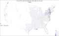
 LibertyUnionPresidentialCounty1860.gif 2,800 × 2,200; 146 KB
-
 NorthernDemocraticPresidentialCounty1860.gif 2,800 × 2,200; 201 KB
-
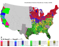
 PresidentialCounty1860.gif 2,800 × 2,200; 248 KB
-
 RepublicanPresidentialCounty1860.gif 2,800 × 2,200; 189 KB
-
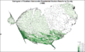
 SouthernDemocraticPresidentialCounty1860.gif 2,800 × 2,200; 207 KB
-
 1860prescountymap.PNG 1,513 × 983; 155 KB
-
 CartogramConstitutionalUnionPresidentialCounty1860Colorbrewer.gif 2,800 × 1,700; 169 KB
-
 CartogramNorthernDemocraticPresidentialCounty1860Colorbrewer.gif 2,800 × 1,700; 175 KB
-
 CartogramPresidentialCounty1860Colorbrewer.gif 2,800 × 1,700; 232 KB
-
 CartogramRepublicanPresidentialCounty1860Colorbrewer.gif 2,800 × 1,700; 179 KB
-
 CartogramSouthernDemocraticPresidentialCounty1860Colorbrewer.gif 2,800 × 1,700; 177 KB
-
 ConstitutionalUnionPresidentialCounty1860Colorbrewer.gif 2,800 × 1,700; 135 KB
-
 County1860.svg 1,260 × 990; 7.49 MB
-
 FusionPresidentialCounty1860Colorbrewer.gif 2,800 × 1,700; 117 KB
-
 NorthernDemocraticPresidentialCounty1860Colorbrewer.gif 2,800 × 1,700; 135 KB
-
 PresidentialCounty1860Colorbrewer.gif 2,800 × 1,700; 190 KB
-
 SouthernDemocraticPresidentialCounty1860Colorbrewer.gif 2,800 × 1,700; 145 KB


