Category:1858 maps of North America
Jump to navigation
Jump to search
Temperate regions: North America · South America · Africa · Europe · Asia · – Polar regions: – Other regions:
English: 1858 maps of North America
Subcategories
This category has the following 2 subcategories, out of 2 total.
C
U
Media in category "1858 maps of North America"
The following 5 files are in this category, out of 5 total.
-
 Nord-America.jpg 5,738 × 4,646; 7.2 MB
-

-
 Map exhibiting the lines of march passed over by the troops of the United States (NYPL b20643923-5591209).tiff 10,328 × 7,760, 2 pages; 229.61 MB
-
 Verein-Staaten von Nord-America, Mexico, Yucatan u. A.jpg 5,760 × 4,666; 9.06 MB
-
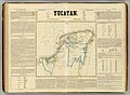 Yucatan 1858 Atlas Mexicano.jpg 1,536 × 1,123; 292 KB

.jpg)

