Category:1856 U.S. presidential election maps, county subdivisions
Jump to navigation
Jump to search
Media in category "1856 U.S. presidential election maps, county subdivisions"
The following 15 files are in this category, out of 15 total.
-
 AmericanPresidentialCounty1856Colorbrewer.png 2,800 × 1,700; 186 KB
-
 CartogramAmericanPresidentialCounty1856Colorbrewer.png 2,800 × 1,700; 255 KB
-
 CartogramDemocraticPresidentialCounty1856Colorbrewer.png 2,800 × 1,700; 271 KB
-
 CartogramOtherPresidentialCounty1856Colorbrewer.png 2,800 × 1,700; 228 KB
-
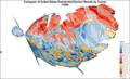 CartogramPresidentialCounty1856Colorbrewer.png 2,800 × 1,700; 303 KB
-
 CartogramRepublicanPresidentialCounty1856Colorbrewer.png 2,800 × 1,700; 255 KB
-
 DemocraticPresidentialCounty1856.png 2,800 × 2,200; 177 KB
-
 DemocraticPresidentialCounty1856Colorbrewer.png 2,800 × 1,700; 197 KB
-
 John C. Fremont, America's Future Through Democracy 1856 Cornell.jpg 2,618 × 1,577; 1.48 MB
-
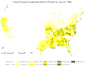 KnowNothingPresidentialCounty1856.gif 2,800 × 2,200; 200 KB
-
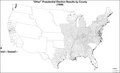 OtherPresidentialCounty1856Colorbrewer.png 2,800 × 1,700; 157 KB
-
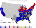 PresidentialCounty1856.gif 2,800 × 2,200; 227 KB
-
 PresidentialCounty1856Colorbrewer.gif 2,800 × 1,700; 170 KB
-
 RepublicanPresidentialCounty1856.gif 2,800 × 2,200; 185 KB
-
 RepublicanPresidentialCounty1856Colorbrewer.png 2,800 × 1,700; 179 KB


