Category:1850s maps of Jerusalem
Jump to navigation
Jump to search
Media in category "1850s maps of Jerusalem"
The following 26 files are in this category, out of 26 total.
-

-
 Bible dictionary for the use of Bible classes, schools and families (1851) (14760863266).jpg 3,424 × 2,284; 1.47 MB
-
 18 of '(A History of the Romans under the Empire.)' (11039098214).jpg 1,427 × 2,460; 448 KB
-

-
-
 HEINZELMANN(1854) 13.531 Kartenblatt Palästina.jpg 2,443 × 2,963; 3.55 MB
-
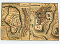 Ancient Jerusalem Modern Jerusalem.jpg 1,485 × 1,094; 1.21 MB
-

-
 234 of 'Sinai and Palestine, in connection with their history' (11049984914).jpg 1,434 × 1,550; 574 KB
-
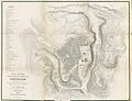
 236 of '(Sinai and Palestine, in connection with their history.)' (11050403676).jpg 1,409 × 1,531; 464 KB
-

-

-

-
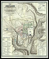
 1858 map of Jerusalem and environs.jpg 8,000 × 6,383; 13.03 MB
-
-

-
-

-
 1859 - Zug der Israeliten aus Ägypten nach Kanaan.jpg 1,556 × 2,283; 1.4 MB
-
 Stieler - Jerusalem in the 70s and the 1850s.jpg 851 × 2,027; 929 KB
-
 The gems of masonry - emblematic and descriptive (1859) (14723708556).jpg 3,760 × 2,180; 1.26 MB
-
 The gems of masonry - emblematic and descriptive (1859) (14746416342).jpg 3,686 × 2,592; 1.8 MB
-
 CONRAD(1859) p503 PLATTE GROND VAN JERUZALEM.jpg 1,866 × 2,460; 2.47 MB
-
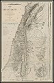
 Charles William Meredith van de Velde, Map of the Holy Land 08 (FL199992301 2369094).jpg 7,312 × 6,048; 21.37 MB
-
 Mount of Olives 1858.jpg 781 × 731; 113 KB
-
 VanDeVeldeMap8.jpg 4,251 × 3,527; 2.63 MB

_(14760863266).jpg)
%27_(11039098214).jpg)


_13.531_Kartenblatt_Pal%C3%A4stina.jpg)

.jpg)
.jpg)
%27_(11050403676).jpg)
%27_(11053153806).jpg)
%27_(11053292735).jpg)
%27_(11051362365).jpg)


_(14723708556).jpg)
_(14746416342).jpg)
_p503_PLATTE_GROND_VAN_JERUZALEM.jpg)
.jpg)

