Category:1840s maps of England and Wales
Jump to navigation
Jump to search
Subcategories
This category has the following 2 subcategories, out of 2 total.
1
- 1840s maps of Wales (1 F)
Media in category "1840s maps of England and Wales"
The following 7 files are in this category, out of 7 total.
-
 The Inland Navigation, Rail Roads, Geology and Minerals of England & Wales.jpg 12,790 × 15,412; 34.3 MB
-
 A new map of England & Wales from the best authorities - btv1b53087473v.jpg 6,368 × 8,248; 7.89 MB
-
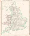
 Barclay's Dictionary England and Wales.jpg 4,713 × 6,101; 20.25 MB
-

-
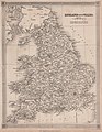
 England und das Fürstenthum Wales Platt 1848.pdf 2,414 × 2,872; 736 KB
-

-


.jpg)
.jpg)
.jpg)