Category:1805 maps of the United States
Jump to navigation
Jump to search
Countries of the Americas: Canada · United States of America
States of the United States: Massachusetts · Ohio
Subcategories
This category has the following 4 subcategories, out of 4 total.
M
- 1805 maps of Massachusetts (1 F)
O
- 1805 maps of Ohio (2 F)
Media in category "1805 maps of the United States"
The following 25 files are in this category, out of 25 total.
-
-
-
 A Map of the United States and part of Louisiana. LOC 98685610.jpg 6,470 × 5,097; 5.21 MB
-

-

-
 Carte des Etats-Unis de l'Amérique suivant le Traité de paix de (espace vide) LOC 2003630526.jpg 12,073 × 6,707; 13.82 MB
-

-
 LowesMap.jpg 3,707 × 2,958; 5.27 MB
-

-
 Map of a portion of Feliciana District, Spanish West Florida. LOC 2013585044.jpg 4,755 × 7,739; 5.06 MB
-
 Map of a portion of Feliciana District, Spanish West Florida. LOC 2013585045.jpg 6,661 × 4,522; 3.92 MB
-
 Map of a portion of Manchac District, Spanish West Florida. LOC 2013585039.jpg 5,723 × 3,735; 2.87 MB
-
 Map of an area along Bayou Bogue Chitto, Spanish West Florida. LOC 2013585032.jpg 6,039 × 4,711; 3.61 MB
-
 Map of an area from Pearl River to Bay St. Louis in Spanish West Florida. LOC 2013585030.jpg 5,204 × 3,861; 2.47 MB
-

-

-

-

-

-
 Map of Feliciana District, Spanish West Florida, along Bayour Sara. LOC 2013585041.jpg 4,490 × 8,412; 4.8 MB
-
 Map of Feliciana District, Spanish West Florida. LOC 2012593386.jpg 9,329 × 8,682; 10.55 MB
-

-
-
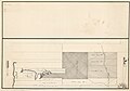 Plan of Baton Rouge and adjoining properties on the Mississippi River. LOC 2013586081.jpg 7,905 × 5,501; 5.39 MB
-
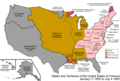 United States 1805-01-1805-07.png 1,000 × 677; 106 KB
_-_Geographicus_-_WesternTerritory-cary-1805.jpg)


.jpg)
_LOC_2003630526.jpg)


_LOC_2013593252.jpg)

