Category:1800s maps of Tennessee
Jump to navigation
Jump to search
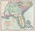
States of the United States: Alabama · Alaska · Connecticut · Delaware · Florida · Georgia · Illinois · Indiana · Kentucky · Louisiana · Maine · Maryland · Massachusetts · Michigan · Minnesota · Mississippi · Missouri · New Hampshire · New Jersey · New York · North Carolina · Ohio · Pennsylvania · Rhode Island · South Carolina · Tennessee · Vermont · Virginia – Washington, D.C.
Puerto Rico
Puerto Rico
Media in category "1800s maps of Tennessee"
The following 3 files are in this category, out of 3 total.
-

-
-
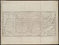 A map of the Tennassee state formerly part of North Carolina (3045318235).jpg 2,000 × 1,527; 2.5 MB


.jpg)