Category:17th-century maps of the Sea of Marmara
Jump to navigation
Jump to search
Media in category "17th-century maps of the Sea of Marmara"
The following 28 files are in this category, out of 28 total.
-

-
 UBBasel Map 1601 Kartenslg AA 89a-c Graecia.tiff 14,042 × 6,362, 4 pages; 650.09 MB
-
 Salvator Oliva. Mediterranean. HM 2515. PORTOLAN ATLAS. Marseilles, 1619.E.jpg 1,434 × 1,089; 504 KB
-
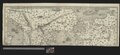
 1624 - Carte de la Mer Egée et de la Mer de Marmara.jpg 10,438 × 17,120; 26.66 MB
-

-

-
 OPAKH. Thraciae Veteris Typus.jpg 2,085 × 1,600; 930 KB
-
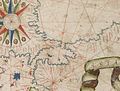
 Sea of Marmara - Taboas geraes de toda a navegação LOC 78653638-21 (cropped).tif 3,896 × 1,694; 18.88 MB
-
 Sea of Marmara - Taboas geraes de toda a navegação LOC 78653638-24 (cropped).tif 2,854 × 2,744; 22.41 MB
-
 Taboas geraes de toda a navegação LOC 78653638-21.tif 9,157 × 5,514; 144.46 MB
-

-
 Constantinople, Thraciæ veteris Typus.jpg 1,223 × 971; 376 KB
-
 Sea of Marmara - 1646 map of the Aegean Sea by Robert Dudley (cropped).jpg 4,318 × 1,607; 721 KB
-
 1646 map of the Aegean Sea by Robert Dudley.pdf 4,454 × 2,952; 1.89 MB
-
 Thraciae delineatio - (par le Père Philippe Briet) - btv1b5962147p.jpg 3,016 × 2,488; 1.14 MB
-
 1660 Portolan chart of the Aegean Sea and the Sea of Marmara by Jean-François Roussin.jpg 7,962 × 5,733; 5.41 MB
-
 Thrace, by Joan Janssonius - 1662.jpg 2,238 × 1,700; 2.07 MB
-
 1662 Portolan chart of the Aegean Sea and the Sea of Marmara by François Ollive.jpg 5,322 × 3,452; 2.47 MB
-

-
 Atlante Veneto Volume 2 064.jpg 10,359 × 7,001; 7.53 MB
-
-

-
 17th- or 18th-century manuscript map - Carte de la Mer Marmara, du Bosphore et des Dardanelles.jpg 24,553 × 10,364; 32.08 MB
-

-

-

-
 17th-century manuscript map - Petites îles auprès de celle de Marmara.jpg 1,344 × 1,072; 235 KB
-


.jpg)
.jpg)


_-_btv1b5962147p.jpg)


.jpg)


.jpg)
.jpg)