Category:17th-century maps of the North Sea
Jump to navigation
Jump to search
Media in category "17th-century maps of the North Sea"
The following 10 files are in this category, out of 10 total.
-
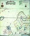
 Map of Scandinavia (1600) North east.jpg 800 × 600; 156 KB
-
 Tabula hydrographica - no-nb krt 00479.jpg 7,795 × 10,157; 22.03 MB
-
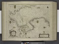
 Comberford, The Northern Navigation.jpg 1,504 × 1,805; 1.26 MB
-

-
 Blaeu 1645 - Novus XVII Inferioris Germaniæ Provinciarum typus.jpg 3,614 × 3,040; 1.97 MB
-
 Breeveertien op Pascaart van de Noort zee (NYPL b13908778-1619022).jpg 910 × 585; 185 KB
-
 De Nordseeküste (Karten) 01.jpg 3,856 × 3,433; 2.48 MB
-
 Pascaart van de Noort zee (NYPL b13908778-1619022).tiff 7,230 × 5,428; 112.28 MB
-
 Pascaart van de Noord Zee, van Texel tot de Hoofden (NYPL b13908778-1619025).jpg 5,508 × 4,554; 7.01 MB
-

_North_east.jpg)


.jpg)

.jpg)
_01.jpg)
.jpg)
_RP-P-1896-A-19368-3010.jpg)