Category:17th-century Native American history
Jump to navigation
Jump to search
Subcategories
This category has the following 24 subcategories, out of 24 total.
#
1
B
C
L
- Byrd Leibhart Site (36YO170) (2 F)
O
- Old Indian Meeting House (13 F)
P
R
- Richard T. Foley Site (4 F)
S
W
- Wampum belt (Peabody Museum) (2 F)
Media in category "17th-century Native American history"
The following 33 files are in this category, out of 33 total.
-
 "Florida et Regiones Vicinae" (9124298123).jpg 2,500 × 1,961; 7.42 MB
-
 1683 Deed from Sachem Mamanuah to Alderman in Little Compton.jpg 2,056 × 2,788; 812 KB
-
 2Minaquos Path-Marker (cropped).jpg 1,275 × 1,245; 671 KB
-
 2Minaquos Path-Marker.jpg 1,836 × 3,264; 2.67 MB
-
-

-
 Cushnoc Trading Post, Maine Commemorative Tablet.jpeg 1,280 × 960; 241 KB
-
 Deed 1661 signed at Rehoboth Massachusetts Indian land sale.png 447 × 788; 26 KB
-
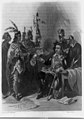
 Dutch Governor and Indian delegation.jpg 1,728 × 906; 443 KB
-
 FLSP P1120749 (25183240413).jpg 1,024 × 768; 109 KB
-
 FLSP P1120752 (25714767161).jpg 576 × 768; 60 KB
-
 Governor Carver 1870 LCCN89707285 (cropped).tif 306 × 366; 110 KB
-
 Hubbard book with map, 1677.jpg 1,864 × 950; 543 KB
-
 Indigenous people of Everglades map.jpg 2,197 × 2,249; 479 KB
-
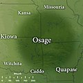 Map of Traditional Osage Tribal Lands by Late 17th Century.jpg 400 × 400; 43 KB
-

-
-

-
 Mille Lacs Lake historical marker.jpg 1,683 × 2,283; 1.32 MB
-
 NouvSuede.jpg 1,146 × 1,151; 1.05 MB
-
 Olentangy Battle Monument.jpg 4,032 × 3,024; 4.4 MB
-
 R P Bolton, indicating Native American Paths in Manhattan ,rendered 1922.jpg 1,372 × 1,372; 1.48 MB
-
 Shorakkopoch rock plaque jeh.jpg 4,000 × 3,200; 2.98 MB
-
 Strickler Site from River Road.jpg 6,016 × 4,000; 6.48 MB
-
 Tanasi-thc-marker-tn1.jpg 1,199 × 899; 444 KB
-

-
 Unburial of Pocahontas. Detail-plaque.jpg 960 × 720; 111 KB
-
 Upper Canada and the Iroquois Confederacy.jpg 1,050 × 1,531; 303 KB
-
 Veterans Memorial Park, Lewiston, Maine.jpg 3,000 × 2,250; 2 MB
-
 Walter Gendall plaque.jpg 3,654 × 2,741; 4.96 MB
-
 Wôpanâak Nation c 1620-01.svg 512 × 374; 79 KB
-
 York 2017.jpg 4,608 × 3,456; 14.7 MB
-
 Zuniga Map.jpg 456 × 600; 38 KB
.jpg)

.jpg)

.jpg)


.jpg)
.jpg)


.jpg)


.jpg)


