Category:1781 maps of New Jersey
Jump to navigation
Jump to search
Media in category "1781 maps of New Jersey"
The following 19 files are in this category, out of 19 total.
-
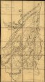
 A map containing part of the Provinces of New York and New Jersey, LOC gm71005417.jpg 11,006 × 20,254; 27.97 MB
-
 A map containing part of the Provinces of New York and New Jersey, LOC gm71005417.tif 11,006 × 20,254; 637.77 MB
-
 A map of Monmouth County. LOC gm72003604.jpg 16,217 × 9,048; 14.52 MB
-
 A map of Monmouth County. LOC gm72003604.tif 16,217 × 9,048; 419.8 MB
-
 A map of part of the province of Jersey. LOC gm72003589.jpg 8,264 × 6,151; 6.3 MB
-
 A map of part of the province of Jersey. LOC gm72003589.tif 8,264 × 6,151; 145.43 MB
-
 A map, Middlesex County. LOC gm72003603.jpg 8,665 × 7,694; 6.65 MB
-
 A map, Middlesex County. LOC gm72003603.tif 8,665 × 7,694; 190.74 MB
-
 A map, Somerset County. LOC gm72003602.jpg 8,172 × 5,829; 5.48 MB
-
 A map, Somerset County. LOC gm72003602.tif 8,172 × 5,829; 136.28 MB
-

-

-
 A sketch of the northern parts of New Jersey. LOC gm72003605.jpg 10,324 × 11,900; 16.35 MB
-
 A sketch of the northern parts of New Jersey. LOC gm72003605.tif 10,324 × 11,900; 351.49 MB
-
 Carte de la Pensylvanie et du Nouveau Jersey (NYPL b15346084-433617).jpg 4,479 × 2,633; 2.25 MB
-

-

-
 Position du camp de l'armée combinée a Philipsburg du 6 juillet au 19 aoust. LOC gm71000986.jpg 12,676 × 5,216; 6.97 MB
-
 Position du camp de l'armée combinée a Philipsburg du 6 juillet au 19 aoust. LOC gm71000986.tif 12,676 × 5,216; 189.17 MB


.jpg)
.jpg)