Category:1780s maps of Alabama
Jump to navigation
Jump to search
States of the United States: Alabama · Alaska · Arkansas · California · Connecticut · Delaware · Florida · Georgia · Illinois · Indiana · Kentucky · Louisiana · Maryland · Massachusetts · Michigan · Mississippi · Missouri · Montana · New Hampshire · New Jersey · New York · North Carolina · North Dakota · Ohio · Pennsylvania · Rhode Island · South Carolina · Vermont · Virginia · Wisconsin – Washington, D.C.
Puerto Rico
Puerto Rico
Subcategories
This category has the following 2 subcategories, out of 2 total.
- 1780 maps of Alabama (4 F)
- 1788 maps of Alabama (1 F)
Media in category "1780s maps of Alabama"
The following 5 files are in this category, out of 5 total.
-
-
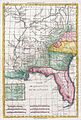
 Map of Louisiana, from d'Anville's atlas. LOC 74690502.jpg 6,536 × 5,020; 3.87 MB
-
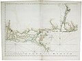 The coast of Alabama, Mississippi and Louisiana RMG K0877.jpg 1,280 × 945; 767 KB
-
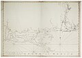 The coast of Alabama, Mississippi and Louisiana RMG K0878.jpg 1,280 × 906; 726 KB
-
 The north east shore of the Gulph of Mexico. LOC 75693439.tif 24,743 × 9,174; 649.43 MB


