Category:1765 maps of France
Jump to navigation
Jump to search
Media in category "1765 maps of France"
The following 7 files are in this category, out of 7 total.
-
 Ile de Bréhat et entrées de rivière du Trieux - Grouillez - btv1b53153894m.jpg 8,804 × 6,168; 5.42 MB
-
 Jean Lattré, Plan de la ville de Paris et de ses Faubourgs, 1765 - Gallica.jpg 9,696 × 6,912; 13.94 MB
-
 Jeu des cartes géographiques - S. L. Hegrad (19) - La France.jpg 1,573 × 2,761; 613 KB
-
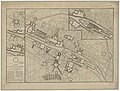 Partie du Plan général de Paris by Pierre Patte - Gallica.jpg 8,208 × 6,223; 10.32 MB
-
 Partie du Plan général de Paris by Pierre Patte - Gallica.png 1,351 × 1,054; 1.95 MB
-
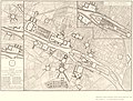 Partie du plan général de Paris by Pierre Patte - Stanford Libraries.jpg 7,398 × 5,625; 8.34 MB
-
 Partie du plan général de Paris by Pierre Patte - Stanford Libraries.tif 7,398 × 5,625; 39.71 MB


_-_La_France.jpg)


