Category:1755 maps of Châlons-en-Champagne
Jump to navigation
Jump to search
Media in category "1755 maps of Châlons-en-Champagne"
The following 8 files are in this category, out of 8 total.
-
 Plan 1755 Châlons abbaye de Toussaint couvent dominicains.JPG 1,064 × 806; 261 KB
-
 Plan 1755 Châlons abbaye st-Pierre bast Aumale st-Jean.JPG 1,092 × 1,028; 224 KB
-
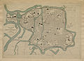
 Plan 1755 Châlons ES 17602 1 (cropped).JPG 1,074 × 718; 281 KB
-
 Plan 1755 Châlons ES 17602 1.JPG 5,344 × 3,928; 2.55 MB
-
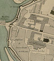
 Plan 1755 Châlons Mathurin collège st-Antoine.JPG 1,485 × 756; 323 KB
-
 Plan 1755 Châlons Notre-Dame st-Alpin.JPG 761 × 619; 156 KB
-
 Plan 1755 Châlons porte Marne cathédrale 1.JPG 680 × 768; 107 KB
-
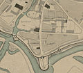 Plan 1755 Châlons porte ste-Croix Vinez Augustins.JPG 1,127 × 983; 389 KB


.JPG)


