Category:1751 map of Virginia and Maryland by Thomas Jefferys
Jump to navigation
Jump to search
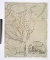
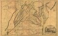
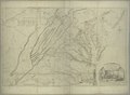
English: Map first published in 1751 and 1755 by Thomas Jefferys. Near-identical copies, usually including Jefferys' cartouche, were brought into circulation by Joshua Fry and Peter Jefferson in 1775. Another wave of republished version occured in 1794.
Media in category "1751 map of Virginia and Maryland by Thomas Jefferys"
The following 23 files are in this category, out of 23 total.
.jpg)


.jpg)
.jpg)