Category:1700s maps of Baden-Württemberg
Jump to navigation
Jump to search
Federal states of Germany:
Subcategories
This category has only the following subcategory.
+
Media in category "1700s maps of Baden-Württemberg"
The following 40 files are in this category, out of 40 total.
-

-

-

-

-

-

-

-

-

-

-
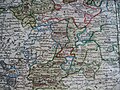
 Chorographia ducatus Wurtenburgici - CBT 5877570.jpg 5,934 × 4,760; 7.35 MB
-
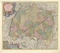
 Circulus Suevicus - CBT 5877230.jpg 5,600 × 4,760; 8.07 MB
-
 LASB K Hellwig 0945.jpg 2,401 × 2,073; 8.66 MB
-

-
 Ducatus Wurtenbergensis (8342804155).jpg 658 × 800; 206 KB
-

-

-
 UBBasel Map 1705 Kartenslg Schw B 47 Lorraine.tiff 16,459 × 7,866, 2 pages; 370.43 MB
-
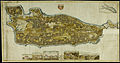 Insel Reichenau Karte 1707.jpg 4,775 × 2,496; 3.24 MB
-
 LASB K Hellwig 0273.jpg 9,940 × 7,275; 16.92 MB
-
 Albtal-1708-Detail-links.jpg 1,338 × 2,000; 911 KB
-
 Albtal-1708-Detail-oben.jpg 2,000 × 1,192; 604 KB
-
 Albtal-1708-Detail-rechts.jpg 2,000 × 1,390; 814 KB
-
 Albtal-1708.jpg 2,000 × 694; 438 KB
-

-

-

-
 Estates of Imperial Knights.jpg 1,600 × 1,200; 628 KB
-
 Karte der zum Kloster Heiligkreuztal gehörigen Waldungen 1700.jpg 2,683 × 1,982; 1,004 KB
-
 Karte1.jpg 4,388 × 3,196; 5.1 MB
-
 Konstanz Marquard Rudolph von Rodt mit Bistumskarte detail Karte.jpg 1,197 × 1,184; 728 KB
-
 Konstanz Marquard Rudolph von Rodt mit Bistumskarte.jpg 2,083 × 2,596; 2.57 MB
-
 Labw-6-959044-1.jpg 405 × 517; 44 KB
-
 LASB K Hellwig 0290.jpg 7,786 × 11,784; 21.71 MB
-

-
 Map - Special Collections University of Amsterdam - OTM- HB-KZL 32.01.24.tif 7,102 × 6,257; 127.14 MB
-

-
 Swabia in the late 18th century.jpg 1,600 × 1,200; 617 KB
-
 Theatrum Belli Rhenani 1703 1712 Blatt 14 Detail Schefflenztal.jpg 4,000 × 3,000; 1.25 MB
-
 Totius S R I Circuli Suevici Tabula Chorographica.jpg 3,305 × 4,018; 11.89 MB
heni_superioris_(inferioris),_Mosae_et_Mosellae_tabula_-_ac_minores_in_eosdem_in_fluentes_Fluvii,_cum_omnibus_adherentibus_regionibus_sicut_Archiepiscopatus_et_Electoratus,_Moguntini_et_Palatinatus..._-_btv1b10223304s.jpg)
.jpg)
.jpg)
.jpg)
.jpg)
.jpg)
.jpg)
.jpg)
.jpg)
.jpg)


_;_R._Cordier_Abbevil_sculp_-_btv1b8495309v.jpg)
.jpg)
.jpg)
.jpg)


.jpg)
.jpg)
.jpg)


_Ducatus_una_cum_insertis_et_adjacentibus_Regionibus,_accuratissime_in_earundem_particulares_provincias_divisum_(8343083748).jpg)


