Category:16 Wojska Polskiego Street in Kłodzko
Jump to navigation
Jump to search
| Object location | | View all coordinates using: OpenStreetMap |
|---|
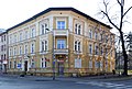
house in Kłodzko, Lower Silesian Voivodeship, Poland .jpg) | |||||
| Upload media | |||||
| Instance of | |||||
|---|---|---|---|---|---|
| Location | Kłodzko, Kłodzko County, Lower Silesian Voivodeship, Poland | ||||
| Street address |
| ||||
| Heritage designation |
| ||||
| Inception |
| ||||
 | |||||
Polski: dom, 3 ćw. XIX w. - Kłodzko, ul. Wojska Polskiego 16
Media in category "16 Wojska Polskiego Street in Kłodzko"
The following 49 files are in this category, out of 49 total.
-
 Kłodzko, ul. Wojska Polskiego 16.jpg 1,820 × 1,500; 1.93 MB
-
 2014 Kłodzko ul. Wojska Polskiego 16 01.JPG 3,884 × 2,625; 7.61 MB
-
 2014 Kłodzko ul. Wojska Polskiego 16 02.JPG 2,689 × 3,744; 6.12 MB
-
 2014 Kłodzko ul. Wojska Polskiego 16 03.JPG 3,824 × 2,331; 5.62 MB
-
 2014 Kłodzko ul. Wojska Polskiego 16 04.JPG 2,487 × 3,829; 6.08 MB
-
 2014 Kłodzko ul. Wojska Polskiego 16 05.JPG 2,696 × 3,672; 7.15 MB
-
 2014 Kłodzko ul. Wojska Polskiego 16 06.JPG 2,543 × 3,866; 7.61 MB
-
 2014 Kłodzko ul. Wojska Polskiego 16 07.JPG 2,739 × 3,896; 7.65 MB
-
 2014 Kłodzko ul. Wojska Polskiego 16 08.JPG 2,158 × 3,828; 5.34 MB
-
 2014 Kłodzko ul. Wojska Polskiego 16 09.JPG 2,491 × 3,866; 8.14 MB
-
 2014 Kłodzko ul. Wojska Polskiego 16 10.JPG 2,481 × 3,828; 6.67 MB
-
 2014 Kłodzko ul. Wojska Polskiego 16 11.JPG 2,563 × 3,871; 6.07 MB
-
 2014 Kłodzko ul. Wojska Polskiego 16 12.JPG 2,523 × 3,643; 4.22 MB
-
 2014 Kłodzko ul. Wojska Polskiego 16 13.JPG 2,272 × 3,718; 4.93 MB
-
 2014 Kłodzko ul. Wojska Polskiego 16 14.JPG 2,208 × 3,672; 4.51 MB
-
 2014 Kłodzko ul. Wojska Polskiego 16 15.JPG 2,170 × 2,535; 2.41 MB
-
 2024 Kłodzko, ul. Wojska Polskiego 16 (1).jpg 3,835 × 2,828; 6.97 MB
-
 2024 Kłodzko, ul. Wojska Polskiego 16 (2).jpg 3,675 × 3,028; 7.11 MB
-
 2024 Kłodzko, ul. Wojska Polskiego 16 (3).jpg 4,026 × 2,998; 8.19 MB
-
 2024 Kłodzko, ul. Wojska Polskiego 16 (4).jpg 3,898 × 3,048; 7.38 MB
-
 2024 Kłodzko, ul. Wojska Polskiego 16 (5).jpg 3,707 × 2,882; 6.15 MB
-
 Kłodzko, Wojska Polskiego 16, 01.JPG 3,528 × 2,559; 4.21 MB
-
 Kłodzko, Wojska Polskiego 16, 02.JPG 2,628 × 3,544; 4.51 MB
-
 Kłodzko, Wojska Polskiego 16, 03.JPG 2,634 × 3,471; 4.05 MB
-
 Kłodzko, Wojska Polskiego 16, 04.JPG 3,308 × 2,552; 4.43 MB
-
 Kłodzko, Wojska Polskiego 16, 05.JPG 2,302 × 3,589; 1.41 MB
-
 Kłodzko, Wojska Polskiego 16, 06.JPG 2,325 × 3,516; 4.42 MB
-
 Kłodzko, Wojska Polskiego 16, 07.JPG 2,538 × 3,546; 4.58 MB
-
 Kłodzko, Wojska Polskiego 16, 08.JPG 2,182 × 3,544; 4.25 MB
-
 Kłodzko, Wojska Polskiego 16, 09.JPG 3,307 × 2,303; 4.13 MB
-
 Kłodzko, Wojska Polskiego 16, 10.JPG 3,013 × 2,481; 4.01 MB
-
 Kłodzko, Wojska Polskiego 16, 11.JPG 3,190 × 2,645; 4.5 MB
-
 Kłodzko, Wojska Polskiego 16, 12.JPG 3,648 × 2,736; 4.94 MB
-
 Kłodzko, Wojska Polskiego 16, 13.JPG 3,603 × 2,736; 4.8 MB
-
 Kłodzko, Wojska Polskiego 16, 14.JPG 2,544 × 3,504; 4.66 MB
-
 Kłodzko, Wojska Polskiego 16, 15.JPG 2,424 × 3,444; 4.42 MB
-
 Kłodzko, Wojska Polskiego 16, 16.JPG 3,189 × 2,599; 4.36 MB
-
 Kłodzko, Wojska Polskiego 16, 17.JPG 3,544 × 2,540; 4.11 MB
-
 Kłodzko, Wojska Polskiego 16, 18.JPG 3,307 × 2,186; 3.84 MB
-
 Kłodzko, Wojska Polskiego 16, 19.JPG 3,347 × 2,526; 4.19 MB
-
 Kłodzko, Wojska Polskiego 16, 20.JPG 3,425 × 2,500; 4.46 MB
-
 Kłodzko, Wojska Polskiego 16, 21.JPG 3,544 × 2,547; 4.94 MB
-
 Kłodzko, Wojska Polskiego 16, 22.JPG 3,648 × 2,480; 4.6 MB
-
 Kłodzko, Wojska Polskiego 16, 23.JPG 3,448 × 2,504; 4.73 MB
-
 Wojska Polskiego 16 3.JPG 1,600 × 2,163; 2.16 MB
-
 Wojska Polskiego 16 4.JPG 1,500 × 2,481; 2.16 MB
-
 Wojska Polskiego 16 5.JPG 1,600 × 2,160; 2.03 MB
-
 Wojska Polskiego 16 6.JPG 2,054 × 1,600; 1.81 MB
-
 Wojska Polskiego 16 detal.JPG 1,500 × 1,909; 1.89 MB


.jpg)
.jpg)
.jpg)
.jpg)


