Category:167 & 169 Bedford Street South
Jump to navigation
Jump to search
| Object location | | View all coordinates using: OpenStreetMap |
|---|
building in Liverpool, Merseyside, England, UK  | |||||
| Upload media | |||||
| Instance of | |||||
|---|---|---|---|---|---|
| Location | Liverpool, Merseyside, North West England, England | ||||
| Street address |
| ||||
| Heritage designation |
| ||||
 | |||||
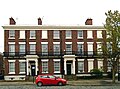
Two 1830s houses forming part of a Grade II listed terrace fronting on to Huskisson Street.
Media in category "167 & 169 Bedford Street South"
The following 3 files are in this category, out of 3 total.
-
 167 & 169 Bedford Street South 1.jpg 4,663 × 3,427; 7.86 MB
-
 167 & 169 Bedford Street South 2.jpg 4,688 × 3,488; 7.42 MB
-
 167 & 169 Bedford Street South.jpg 4,738 × 2,759; 6.65 MB

