Category:1660s maps of the Atlantic Ocean
Jump to navigation
Jump to search
Subcategories
This category has only the following subcategory.
1
Media in category "1660s maps of the Atlantic Ocean"
The following 14 files are in this category, out of 14 total.
-

-
 Paskaarte vertonende alle de zekusten Europe (Pieter Goos, c. 1660).jpg 11,638 × 9,444; 11.85 MB
-

-

-
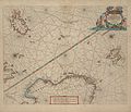 1663 map Pieter Goos northsea norwegian sea.jpg 6,950 × 5,989; 4.1 MB
-
-

-

-

-

-

-
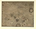
 Pascaarte van Brasil van Rio Grande tot Rio de la Plata... GF 227. Pièce 18.jpg 8,728 × 7,152; 11.45 MB
-

-

.jpg)
.jpg)
.jpg)
_on_1663_map_Pieter_Goos_northsea_norwegian_sea.jpg)

.jpg)
_alle_de_Zeekusten_van_Africa_en_America,_begrepen_in%27t_Octroy_by_de_H._M._H._Staten_generael_der_vereenichde_Nedenl._verleent_aende_generale..._-_btv1b5905569x_(1_of_2).jpg)

.jpg)


