Category:1640s maps of Brazil
Jump to navigation
Jump to search
Subcategories
This category has the following 5 subcategories, out of 5 total.
Media in category "1640s maps of Brazil"
The following 3 files are in this category, out of 3 total.
-
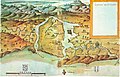 Mapa da Capitania de São Vicente em 1641.jpg 560 × 361; 250 KB
-
 George Marcgraf - Mapa da Paraíba e Rio Grande do Norte, 1643.jpg 640 × 506; 268 KB
-
 Maritima Brasiliæ universæ. R 2= 22. Pièce 74.jpg 8,904 × 6,800; 10.48 MB


