Category:15th-century maps of Europe
Jump to navigation
Jump to search
Temperate regions: North America · Africa · Europe · Asia · Oceania – Polar regions: – Other regions:
Subcategories
This category has the following 44 subcategories, out of 44 total.
#
*
- 15th-century maps of Muscovy (2 F)
B
C
- 15th-century maps of Cyprus (7 F)
E
F
G
- 15th-century maps of Georgia (1 F)
H
- 15th-century maps of Hungary (1 F)
I
- 15th-century maps of Iceland (5 F)
L
N
P
- 15th-century maps of Poland (1 F)
R
- 15th-century maps of Romania (1 F)
- 15th-century maps of Russia (3 F)
S
T
U
Media in category "15th-century maps of Europe"
The following 6 files are in this category, out of 6 total.
-
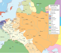 Królestwo Polskie i Wielkie Księstwo Litewskie w 1466 r..svg 1,502 × 1,310; 3.2 MB
-
-

-
 Petrus Roselli. Carte marine de la mer Méditerranée et de la mer Noire (15th century).jpg 9,169 × 7,678; 12.82 MB
-
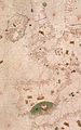
 Portolano anónimo do século XV.jpg 16,261 × 10,058; 20.5 MB
-
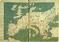 Ptolemaic Europe.jpg 2,119 × 1,519; 346 KB

.P.jpg)
.jpg)
.jpg)

