Category:1590s maps of the Netherlands
Jump to navigation
Jump to search
Countries of Europe: Albania · Armenia‡ · Austria · Belgium · Bosnia and Herzegovina · Bulgaria · Croatia · Cyprus‡ · Denmark · Estonia · Finland · France‡ · Georgia‡ · Germany · Greece · Hungary · Iceland · Republic of Ireland · Italy · Lithuania · Netherlands‡ · Norway · Poland · Portugal‡ · Romania · Russia‡ · Spain‡ · Sweden · Turkey‡ · Ukraine
‡: partly located in Europe
‡: partly located in Europe
Provinces of the Netherlands:
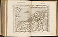
Media in category "1590s maps of the Netherlands"
The following 10 files are in this category, out of 10 total.
-
 1593 Germania Inferior de Jode.jpg 750 × 595; 280 KB
-
 Kaart van Oud Teylingen (1595) (cropped).jpg 2,431 × 2,221; 655 KB
-
 Kaart van Oud Teylingen (1595).jpg 10,000 × 7,007; 6.47 MB
-
 1596 Hollandia Comitatus Kaerius.jpg 2,235 × 2,731; 2.91 MB
-
-
 Abcontrafeitung der Stat Bommel (BM 1872,0113.617).jpg 2,500 × 1,877; 1.52 MB
-
 Gelegenheit des Bommeler Wehrts vnd der Schenckischen Schanzen. (BM 1880,0710.348).jpg 2,500 × 1,510; 772 KB
-
 David de Meyne2.jpg 1,506 × 1,127; 1.9 MB
-

-
 Le Poivre - Klooster Yesse.jpg 1,533 × 1,132; 270 KB

_(cropped).jpg)
.jpg)

_36.jpg)
.jpg)
.jpg)


