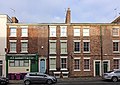
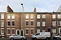
Category:135 - 147 Duke Street, Liverpool
Jump to navigation
Jump to search
| Object location | | View all coordinates using: OpenStreetMap |
|---|
building in Liverpool, Merseyside, England, UK  | |||||
| Upload media | |||||
| Instance of | |||||
|---|---|---|---|---|---|
| Location | Liverpool, Merseyside, North West England, England | ||||
| Heritage designation |
| ||||
 | |||||
Grade II listed late 18th century terrace of houses and shops on Duke Street, Liverpool
Media in category "135 - 147 Duke Street, Liverpool"
The following 5 files are in this category, out of 5 total.
-
 135 - 147 Duke Street, Liverpool 1.jpg 4,672 × 3,310; 8.63 MB
-
 135 - 147 Duke Street, Liverpool 2.jpg 4,873 × 3,227; 8.05 MB
-
 135 - 147 Duke Street, Liverpool 3.jpg 4,928 × 3,144; 8.41 MB
-
 135 - 147 Duke Street, Liverpool stitch.jpg 8,300 × 3,081; 15.31 MB
-
 135-147 Duke Street, Liverpool.jpg 5,152 × 3,864; 7.79 MB


