Category:11 Królewska Street in Lublin
Jump to navigation
Jump to search
| Object location | | View all coordinates using: OpenStreetMap |
|---|
Polski: Lublin, ul. Królewska 11 - pałac tzw. Biskupi, 2 poł. XVIII, poł. XIX
palace in Lublin, Polish–Lithuanian Commonwealth, Poland  | |||||
| Upload media | |||||
| Instance of | |||||
|---|---|---|---|---|---|
| Location | Lublin, Lublin Voivodeship, Poland | ||||
| Street address |
| ||||
| Heritage designation |
| ||||
| Inception |
| ||||
 | |||||
Media in category "11 Królewska Street in Lublin"
The following 3 files are in this category, out of 3 total.
-
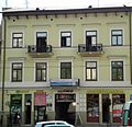 PL Lublin Królewska 11 pałac.jpg 1,920 × 1,855; 2.1 MB
-
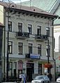 PL Lublin Królewska 11 pałac2.jpg 1,173 × 1,625; 1.24 MB
-
 PL Lublin Królewska 11 pałac3.jpg 2,141 × 1,421; 444 KB

