Category:11/11A Mariensztat Street in Warsaw
Jump to navigation
Jump to search
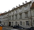
 This is a category related to an object of cultural heritage inscribed in the registry (Warsaw registry) of the Masovian Voivodeship with number 292.

| Object location | | View all coordinates using: OpenStreetMap |
|---|
 | |||||
| Upload media | |||||
| Instance of | |||||
|---|---|---|---|---|---|
| Location | Śródmieście, Warsaw, Masovian Voivodeship, Poland | ||||
| Street address |
| ||||
| Heritage designation |
| ||||
 | |||||
Media in category "11/11A Mariensztat Street in Warsaw"
The following 3 files are in this category, out of 3 total.
-
 Kamienica, poł. XVIII, 1948-50 ul. Mariensztat 11-11 A 2.jpg 3,353 × 2,873; 5.52 MB
-
 Kamienica, poł. XVIII, 1948-50 ul. Mariensztat 11-11 A 3.jpg 2,798 × 2,911; 4.89 MB
-
 Kamienica, poł. XVIII, 1948-50 ul. Mariensztat 11-11 A.jpg 3,236 × 2,904; 3.58 MB

