Category:10 Sikorskiego Street in Krasnystaw
Jump to navigation
Jump to search
| Object location | | View all coordinates using: OpenStreetMap |
|---|
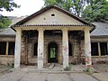
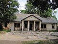
Polski: Krasnystaw, ul. Sikorskiego 10 - Dwór „Starościński” (1 poł. XIX)
dwór in Krasnystaw, Lublin Voivodeship, Poland .JPG) | |||||
| Upload media | |||||
| Instance of | |||||
|---|---|---|---|---|---|
| Location | Krasnystaw, Krasnystaw County, Lublin Voivodeship, Poland | ||||
| Street address |
| ||||
| Heritage designation |
| ||||
| Inception |
| ||||
 | |||||
Media in category "10 Sikorskiego Street in Krasnystaw"
The following 5 files are in this category, out of 5 total.
-
 A 88 Dwór „Starościński” (1 poł. XIX) 2.JPG 2,048 × 1,536; 804 KB
-
 A 88 Dwór „Starościński” (1 poł. XIX).JPG 2,048 × 1,536; 929 KB
-
 Krasnystaw, Dworek "Starosty" - fotopolska.eu (320453).jpg 1,371 × 1,028; 356 KB
-
 Krasnystaw, Dworek "Starosty" - fotopolska.eu (320456).jpg 1,371 × 1,028; 391 KB
-
 Krasnystaw, Dworek "Starosty" - fotopolska.eu (320466).jpg 1,404 × 1,053; 365 KB
_2.JPG)
.jpg)
.jpg)
.jpg)