Category:ⵉⵖⵉⵍ ⵎⴳⵯⵏ
Jump to navigation
Jump to search
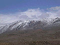
English: The "ⵉⵖⵉⵍ ⵎⴳⵯⵏ" or the "ⵉⵖⵉⵍ ⵎⴳⵓⵏ" (ighil Mgʷn or Mgun, forearm of Mgun) is the local tamazight name written in tifinagh alfabet of M'goun mountain, the 4th highest summit of High Atlas
Walon : L' "ⵉⵖⵉⵍ ⵎⴳⵯⵏ" oudon-bén l' "ⵉⵖⵉⵍ ⵎⴳⵓⵏ" (divant-bresse do Mgoun) , c' est l' no amazir sicrît e l' alfabet tifinar do Mgoun, li cwatrinme pus hôte cresse do Grand Atlasse
mountain in Morocco  | |||||
| Upload media | |||||
| Instance of | |||||
|---|---|---|---|---|---|
| Location | Tinghir Province, Drâa-Tafilalet, Morocco | ||||
| Mountain range | |||||
| Topographic prominence |
| ||||
| Elevation above sea level |
| ||||
 | |||||
Media in category "ⵉⵖⵉⵍ ⵎⴳⵯⵏ"
The following 10 files are in this category, out of 10 total.
-
 Amz-azoul Mgoun lete ⵣ.jpg 2,256 × 1,496; 992 KB
-
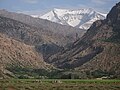 Ighil M'Goun vu depuis Arous.jpg 3,648 × 2,736; 4.36 MB
-
 Ighil Mgon d' Imi n Ifri moto.jpg 1,920 × 1,080; 286 KB
-
 Mgoun mountain peak.jpg 3,500 × 2,287; 2.7 MB
-
 Mgoun voye Demnate Warzazate.JPG 2,256 × 1,496; 825 KB
-
 Mgoun, base camp in the valley.jpg 3,500 × 2,304; 3.67 MB
-
 Mgoun, from base camp, morning.jpg 3,000 × 2,000; 1.58 MB
-
 Mgoun.jpg 250 × 188; 16 KB
-
 Tabant, Ait Bougmez, Maroc.jpg 4,000 × 3,000; 5.72 MB
-
 ⵉⵖⵔⵎ ⵏ ⵎⴳⵓⵏ plake Ayit Bogemmaz.JPG 640 × 360; 125 KB


