Category:Église Saint-Étienne (Kahler)
Jump to navigation
Jump to search
| Object location | | View all coordinates using: OpenStreetMap |
|---|
church building in Luxembourg  | |||||
| Upload media | |||||
| Instance of | |||||
|---|---|---|---|---|---|
| Location | Garnich, Canton of Capellen, Luxembourg | ||||
 | |||||
Media in category "Église Saint-Étienne (Kahler)"
The following 6 files are in this category, out of 6 total.
-
 Chronogramm, Kiercheportal Koler-101.jpg 3,365 × 2,235; 4.94 MB
-
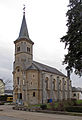
 Kahler church.jpg 2,332 × 2,083; 306 KB
-
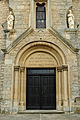 Kiercheportal Koler-101.jpg 2,682 × 4,038; 6.28 MB
-
 Kirche Kahler 01.jpg 1,400 × 2,044; 1.88 MB
-
 Kirche Kahler 02.jpg 1,946 × 1,450; 1.49 MB
-
 Kirche Kahler 03.jpg 1,480 × 1,889; 2.3 MB


