
Brooklands Motor Circuit surviving sections
Members' Banking
[edit]- West end: 51°21′21″N 0°28′05″W / 51.35581°N 0.468078°W
- East end: 51°21′10″N 0°27′37″W / 51.352722°N 0.460342°W
- T-Junction with Finishing Straight: 51°21′23″N 0°27′47″W / 51.356407°N 0.463057°W
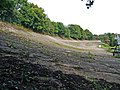
Around two-thirds of the Member's Banking section survives. The bridge over the River Wey removed in WWII was never replaced. Working clockwise, the surviving section from the top of Railway Straight 51°21′21″N 0°28′05″W / 51.35581°N 0.468078°W up to the edge of the bridge 51°21′23″N 0°28′01″W / 51.356286°N 0.466876°W is intact, now part of Mercedes-Benz World. After the missing bridge, the section from 51°21′23″N 0°27′59″W / 51.356521°N 0.466484°W to 51°21′19″N 0°27′37″W / 51.355281°N 0.460348°W (approximately the western 2/3rds of the curve) is also intact, and now belongs to (and marks the northern boundary of) the museum. Also present on this part of the curve is the reconstructed Members' Bridge 51°21′23″N 0°27′44″W / 51.35646°N 0.462327°W, which crosses the track SW-NE, just east of the T-Junction with Finishing Straight (the north part of which is also now in the museum site).
In the final third, working clockwise, the track has given way to:
- A small section has been flattened, from a point roughly in line with the northern gable No. 10 Kingsway Terrace, to the opposite gable end of No. 1. Kingsway Terrace is the row of houses (1-10) and rear cul-de-sac on the south side of Locke King Road. The east side of the track here appears to now be part of the cul-de-sac parking. The west side appears to be a sloped tarmac area used as an overfloew car park for the JTI (Japan Tobacco International) HQ 51°21′15″N 0°27′39″W / 51.354048°N 0.460889°W (they also have a dedicated multi-level parking structure immediately to the south).
- In the rest of the section, the line of the curve is still evident in a tree line along the top of the banking, but the track itself has been covered, in part by the JTI parking structure, and the rest by landsacaping and access road for the JTI building. The treeline now serves as the western boundary of the parking areas of three office blocks of the St Georges Business Park. From north to south, they are: No. 207 Brooklands Road 51°21′17″N 0°27′34″W / 51.354631°N 0.459366°W, No. 205 51°21′15″N 0°27′32″W / 51.354055°N 0.458851°W & No. 203 51°21′12″N 0°27′33″W / 51.353412°N 0.459108°W.
Ammunition stores
[edit]As part of the changes made during WWII, three small brick bunkers were added on the inside of the Members' Banking, in a line immediately to the east of the Members' Bridge - 51°21′23″N 0°27′44″W / 51.356279°N 0.462161°W (east), 51°21′22″N 0°27′43″W / 51.356162°N 0.461892°W (middle), 51°21′22″N 0°27′42″W / 51.356032°N 0.461673°W (west). These were ammunition stores for the anti-aircraft towers that were mounted on the hill.
-
 One of the stores
17 November 2007 -
 The view out of one of the stores to the banking
17 November 2007


Looking east (clockwise)
[edit]-
 Track level, looking north east from the edge of the missing bridge section
1 January 2004 -
 Track level, looking north east from the edge of the missing bridge section
30 September 2007 -
 Track level
Western end, looking north east
22 July 2012 -
 Track level
Western end, looking north east
6 August 2013 -
 Track level, looking east. Member's Bridge in the distance
4 October 1992 -
 Track level, looking east. Member's Bridge in the distance, London Bus Museum on the right
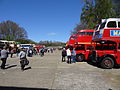
13 April 2014 (bus rally) -
 Track level, looking east to Members' Bridge
22 December 1990 -
 Track level, looking east to Members' Bridge
30 September 2007 -
 13 April 2014 (bus rally)
 -
 13 April 2014 (bus rally)
 -
 Track level, looking east to Members' Bridge
(during filming for The Bill)
10 April 2003 -
 Track level, looking east to Members' Bridge
25 June 2006 -
 Track level, looking east to Members' Bridge
26 February 2012 -
 Track level, looking east to Members' Bridge
22 July 2012 -
 East from Members' Bridge
17 April 2009 -
 East from Members' Bridge (ammunition stores on the right)
17 November 2007 -
 Track level, looking east from beneath Members' Bridge (ammunition stores on the right)
17 November 2007 -
 Track level, looking east from beneath Members' Bridge (ammunition stores on the right)
6 August 2013 -
 East from Members' Bridge (ammunition stores on the left) (end of track visible)
30 September 2007 -
 East from Members' Bridge (ammunition stores on the left)
30 September 2007


.jpg)


.jpg)
.jpg)


.jpg)


Looking west (anti-clockwise)
[edit]-
 Track level, looking west. Just before the Finishing Straight.
17 April 2009 -
 Track level, looking west. Just before the Finishing Straight.
26 February 2012 -
 West from Members' Bridge
30 September 2007 -
 The view west to Members' Bridge (huts on the left)
17 November 2007


Other views
[edit]-
 The view south east under the rail line, to the missing bridge section
11 October 2005 -
 The view north east over the Rivery Wey to the western end of the banking
21 April 2012


Byfleet Banking
[edit]- West end: 51°21′00″N 0°28′40″W / 51.349994°N 0.477691°W
- East end: 51°20′46″N 0°27′57″W / 51.346155°N 0.465792°W
Over three-quarters of the Byfleet Banking survives. Using the features that have since been built on the track, these surviving parts can be broken up into four notional sections of surviving track, with two large gaps. These are, (west to east):
- Section 1: From the western end to 51°20′54″N 0°28′45″W / 51.348242°N 0.479166°W, the track survives, but has been encroached in several places in its lower parts by plots associated with Brooklands Industrial Park on the inside of the oval. The end of this section is marked by a footpath which actually crosses the track, linking Avro Way on the inside of the oval with Wintersells Road on the outside.
- Section 2: From the footpath to 51°20′40″N 0°28′42″W / 51.344526°N 0.478195°W, this surviving section of track also borders plots in the Industrial Park, but with a definite inner boundary still present, it appears not to have been encroached at all. It appears to be significantly overgrown however, perhaps due to the lack of any vehicular access. It also includes at its southern end what appears to be some of the deliberate planting of trees as WWII era camouflaging.
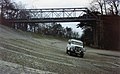
- Gap 1: Section 2 ends at diagonal vertical drop at the edge of a diagonal cutting made through the track for a road. This was originally an access road for a Hawker aircraft factory. It is now a two-lane public road, Barnes Wallis Drive (A318), which merges into Oyster Lane at a junction immediately on the outside.
- Section 3: From the other side of the cutting 51°20′39″N 0°28′40″W / 51.344144°N 0.477777°W, to another break at 51°20′34″N 0°28′23″W / 51.342724°N 0.473099°W, this surviving section of track is paralleled on its inside by the continuation of Barnes Wallis Drive (A318), with a roundabout halfway along which acts as the access for a superstore, whose car park takes up the space on the inside of the road.
- Gap 2: Section 3 ends at a tree line, the other side of which is a large gap in the track. This was originally created for a runway, cutting through it north to south. Now, the west side carries Sopwith Drive (A318), a dual carriageway, with the remaining part being green space.
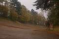
- Section 4: On the other side of the green space, this surviving section of track continues to the east end of the curve. It is lined on both sides by trees, with this area being the Brooklands Community Park (further inside the park is open green space, being the last remains of the airfield, while on the outside the park is all woodland). The Aerodrome Road which ran along the inside of the Byfleet Banking also survives in this section. At the east end, the banking ends just before it bridges over the River Way, which is the start of the straight to Vickers.
Looking east (anti-clockwise)
[edit]-
 Looking south east over the Barnes Wallis Drive cutting
29 October 2008 -
 Western end of the Barnes Wallis Drive section, looking east
26 September 2010 -
 Track level, looking east, Barnes Wallis Drive section, opposite the superstore roundabout
22 July 2012.jpg -
 Track level, looking east, Barnes Wallis Drive section, after the superstore roundabout
15 February 2013.jpg -
 Track level, looking east, from the start of the SE section
26 September 2009 -
 Track level, looking east, midway along the SE section
15 April 2013


Looking west (clockwise)
[edit]-
 Track level, looking west, Barnes Wallis Drive section, towards the superstore roundabout
19 July 2012 -
 Track level, looking west, Barnes Wallis Drive section, towards the cutting
8 November 2009 -
 Track level, looking north west at the Barnes Wallis Drive cutting
15 February 2013 -
 Track level, looking north west at the Barnes Wallis Drive cutting
22 July 2012 -
 Looking west along Barnes Wallis Drive, into the cutting
26 September 2010


The Fork & eastern sections of the oval
[edit]- Member's Banking end (north): 51°21′10″N 0°27′37″W / 51.352722°N 0.460342°W
- The Fork : 51°20′56″N 0°27′54″W / 51.348815°N 0.465009°W (approximate)
- Byfleet Banking end (south): 51°20′46″N 0°27′57″W / 51.346155°N 0.465792°W
Virtually all of the oval that formed the eastern side north and south of The Fork have been lost to subsequent development.
The northern extended S which linked The Fork to Members' Banking has been completely lost to the structures, roads and grounds of the Proctor & Gamble building 51°21′07″N 0°27′42″W / 51.351938°N 0.461705°W and the Sony UK HQ building 51°21′00″N 0°27′46″W / 51.350102°N 0.462713°W inside The Heights business park.
The approximate location of the The Fork is the roundabout in Wellington Way, which provides access to The Heights business park.
The southern straight has been lost to housing, but the line of the straight can be seen (tracking south) by the line of two residential streets, firstly Stanisland Drive as it leaves the Wellington Way roundabout, and then as the road continues as Connaught Drive beyond the T-Junction 51°20′52″N 0°27′55″W / 51.347673°N 0.465326°W with Dixon Drive. Housing occupies the area here, both outside and inside the oval, the inside part being bounded on the west by the course of the River Wey.
The only remaining part of the track is at the southern end of the southern straight, where it meets Byfleet Banking. This is also the point where the River Wey exits the oval, with the bottom of the straight forming the bridge. The end of the track here is defined by the diagonal formed by the north side of this bridge. The other side of the fence is a small green space, beyond which is where Connaught Drive bends away to the east. Immediately to the south of the bridge the actual banking starts, and at this same point, a small section of concreted track also heads east into the oval, but almost immediately becomes conventional tarmac, part of a former taxiway.
-
 Looking east along the former taxiway to the track in the distance
15 April 2013 -
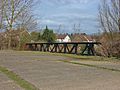 Looking NE across the bridge
15 April 2013 -
 The view south into the start of the Byfleet Banking
15 April 2013


.jpg)
Railway Straight
[edit]- Member's Banking end (north): 51°21′21″N 0°28′05″W / 51.35581°N 0.468078°W
- Byfleet Banking end (south): 51°21′00″N 0°28′40″W / 51.349994°N 0.477691°W
Over two thirds of the Railway Straight survives, in a continuous stretch in its upper end. The lower third has been flattened for two plots of the Brooklands Industrial Park (north to south):
- From 51°21′00″N 0°28′40″W / 51.349994°N 0.477691°W to 51°21′04″N 0°28′34″W / 51.351144°N 0.476012°W
- Taken over by tarmac and the structure of the long, thin unit here: 51°21′02″N 0°28′33″W / 51.350551°N 0.475888°W
- From 51°21′04″N 0°28′34″W / 51.351144°N 0.476012°W to 51°21′08″N 0°28′27″W / 51.352274°N 0.474271°W
- Taken over mostly by the car park/loading area, and partly by the NW corner of, the large rectangular building here: 51°21′06″N 0°28′29″W / 51.351717°N 0.474805°W.
Finishing Straight
[edit]- Member's Banking end (north): 51°21′23″N 0°27′47″W / 51.356407°N 0.463057°W
- The Fork end (south) : 51°20′56″N 0°27′54″W / 51.348815°N 0.465009°W (approximate)
Only small sections of the Finishing Straight survive, but its general location and alignment can still be seen because most of it now forms the long rectangular tarmacced area which contains the car parks for the units in The Heights business park, running from 51°21′15″N 0°27′49″W / 51.354149°N 0.463582°W in the north, to 51°21′01″N 0°27′53″W / 51.350219°N 0.464838°W in the south.
Below the car park stretch, the remaining southern section to The Fork is now formed by the road and landscaping of the access road for the business park, coming north off of the Wellington Way roundabout.
The northern end beyond the business park car park is now inside the grounds of the Brooklands Museum. Their rectangular Wellington Hangar 51°21′19″N 0°27′48″W / 51.355157°N 0.463239°W was built on the straight, being approximately the same width, and placed on the same alignment, as the former track. The section from the hangar to the Members' Banking survives intact. The section below the hangar to the museum boundary is still open, but is now a mixture of later tarmac and original concrete, housing both car parking spaces and open air museum exhibits.
-
 A diagonal view (SE to NW) across the Finishing Straight, just south of the Wellington Hangar
 -
 The view north to Members Banking
13 April 2014 (bus rally) -
 The view north to Members Banking
13 April 2014 (bus rally) -
 The view north to Members Banking
13 April 2014 (bus rally) -
 The view south to the Wellington Hangar
13 April 2014 (bus rally)

.jpg)
.jpg)
.jpg)
.jpg)
Campbell Circuit inner sections
[edit]Various parts of the inner sections of track which formed part of the Campbell Circuit survive.
None of the western parts, where it leaves the Railway Straight and formed the Soloman Straight, survive, with the area now occupied by a Spa and Hotel 51°21′11″N 0°28′15″W / 51.353171°N 0.470738°W, built on a plot which was previously green space. Bricks in the hotel car park, and features in the floor of the reception area inside it, mark out the former path of Solomon Straight.
The middle parts, namely Clubhouse turn, Sahara Straight and Howe's Corner, are all now in the area occupied by Mercedes-Benz World. Much of it survives, as one long section, incorporated into the driving areas to the south of the main building. The surviving concrete begins as a continuation of a tarmac road around the Wet Skid Circle, at a point 51°21′15″N 0°28′05″W / 51.354216°N 0.468083°W halfway around Clubhouse turn, includes the entire Sahara Straight, and ends just after Howe's corner, where the present day handling circuit tarmac branches off to the south.
Heading further west out of Mercedes-benz World toward the river, the alignment can still be seen, but has been covered by tarmac of a now disused road. The bridge section over the river survives, but a fence 51°20′58″N 0°28′00″W / 51.349388°N 0.466613°W at its eastern end marks the point where the track gives way to the landscaping and car park of Building 1 of The Heights business park.
Because of the business park, none of the parts of the Campbell track which crossed and then paralleled the Finishing Straight survive. The eastern end survives however, namely the straight that came down Members Hill, and its two associated curves. The surviving concrete starts 51°21′16″N 0°27′46″W / 51.354313°N 0.46289°W at the top of the straight which paralleled the NNE-SSW aligned Finishing Straight, which is now inside the south east corner of the museum site. This is now the east entrance of the museum - the concrete continues as the curve and then along the SE straight to the main oval, now designated JTI Members Hill as it divides with the JTI (Japan Tobacco International) site to the north east, and The Heights business park to the south west. As JTI Members Hill approaches the oval, the concrete of the Campbell Circuit survives as it makes the final bend north, as Banking Bend, to rejoin the outer oval (but the outer oval concrete no longer survives). JTI Members Hill continues straight on out of the oval to a T-Junction 51°21′09″N 0°27′34″W / 51.352407°N 0.459377°W with Caenswood Hill, joined at a point 51°21′10″N 0°27′37″W / 51.352705°N 0.460213°W on the former oval by an access road for the JTI site, which runs north along the line of the former oval.}}
-
 The view NW up JTI Members Hill, showing the point where the former Campbell Circuit rejoined the main oval as Banking Bend, away to the right
30 September 2007 -
 The view north west across Sahara Straight and the Handling Circuit, to the Spa/Hotel (right)
8 November 2009

