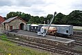
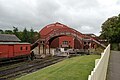
Marking the northern boundary of the Beamish Museum, next to The Town, is a railway. At the western end is a complex comprising a goods area, station and signal box. There are two footbridges at either end, the eastern one linking the station with the road that heads west, to become the main street. All of these elements form the northern border the Events field. Immediately beyond the western bridge, two tracks enter the northern portion of the Beamish Waggon & Iron Works, providing under cover storage. East of the eastern footrbidge, the railway continues as a single track behind the northern edge of the Town, ending at a buffer stop near the tramway.
The Goods yard consists of a Shed with a V-shaped platform extending east, with a crane installed on it; the track to the north continues into the shed, the track on the south platform ends in an open siding. North of the shed is an open storage siding. Another siding to the south continues to the coal drop, with road access to the coal from the resulting triangular shaped yard area between the drop siding and the south shed siding. A weighbridge stands at the road access to the yard, on its southern edge.
The tracks from the station continue west into a double-tracked shed, built into the northern part of the Waggon & Iron Works building. The northern goods track also continues to a buffer stop at the building.


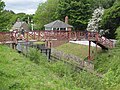
 Showing the station, signal box & eastern bridge
 Showing the station, signal box & eastern bridge
 Showing the station, signal box, eastern bridge & part of the goods shed
 Showing the station, signal box, eastern bridge & part of the goods yard
 Showing the station, signal box, eastern bridge & part of the goods yard
 Showing the station, signal box, eastern bridge & part of the goods yard


.jpg)
.jpg)

 Signal box on the right
 Showing station & signal box
 Showing station & signal box
 Showing western bridge & station
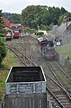 Showing western bridge & station
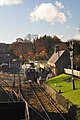 Showing western bridge & station
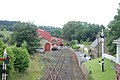 Showing goods shed, iron works doors, western bridge & station
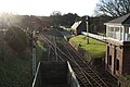 Showing goods shed, station & signal box
 Showing goods shed, station & signal box
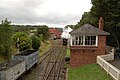 Showing coal drops, goods shed, station & signal box
 Showing the western bridge & station platform
.jpg)

.jpg)

.jpg)


.jpg)

 Showing the goods shed & western bridge
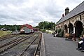 Showing the coal drop, goods shed & western bridge
.jpg)

 The view east from the eastern bridge
 The view east from the eastern bridge
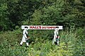 Hall's Distemper advert, a few yards east of the east footbridge, on the north embankment
.jpg)
.jpg)


 From the east
 From the eastern bridge
 From the eastern bridge
 From the west, along the path from the station
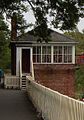 From the west, along the path from the station
.jpg)
.jpg)
.jpg)
.jpg)


 Looking SW
.jpg)
 Viewed from the opposite embankment, to the south east
 Viewed from across the tracks to the goods platforms/coal drop


 Eastern end
 Bench (from the west)


 Western end
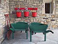 Fire fighting equipment & Ticket window
 Fire fighting equipment
 Ticket window

.jpg)

 Triangular platform, from the SE
 Wagons in the north siding
 Wagons in the north siding
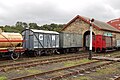 Wagons in the north siding & storage siding
 Wagons in the north siding & storage siding
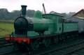 Facing east, in the north platform
 Facing east, in the south platform
 The south side of the shed, showing the open air siding
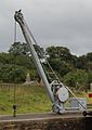 The platform crane

.jpg)
.jpg)
.jpg)
.png)

.jpg)

 From the western footbridge
 From the north, across the main line
.jpg)
.jpg)
 Wagons on the south siding, viewed from inside the coal drops
 Traction engines backed up onto the coal pile from the drops (also showing south siding track)
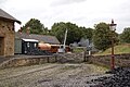 The view east across the south siding/yard
 The view east across the south siding/yard

.jpg)
.jpg)
 the yard side/buffer stop end
 the yard side/buffer stop end
 the yard side/railway end
 north (yard) side
 one of the bays
 WX 6358

.jpg)
.jpg)
.jpg)

 from the SW
 from the NW

 East side
.jpg)


.jpg)

