<nowiki>Bayerisch Gmain; Bayerisch Gmain; Bayerisch Gmain; Байериш-Гмайн; Bayerisch Gmain; Bayerisch Gmain; Bayerisch Gmain; Բայերիշ Գմայն; 巴伐利亚格迈恩; Bayerisch Gmain; Bayerisch Gmain; Bayerisch Gmain; Баєріш-Гмайн; Bayerisch Gmain; 巴伐利亚格迈恩; Bayerisch Gmain; Байериш-Гмайн; Bayerisch Gmain; Bayerisch Gmain; Boarisch Gmoa; Bayerisch Gmain; Bayerisch Gmain; Bayerisch Gmain; Bayerisch Gmain; Bayerisch Gmain; Bayerisch Gmain; Байериш-Гмайн; Байериш-Гмайн; Бајериш Гмајн; Bayerisch Gmain; Bayerisch Gmain; Bayerisch Gmain; Байериш-Гмайн; Bayerisch Gmain; Bayerisch Gmain; Bayerisch Gmain; Bayerisch Gmain; Bayerisch Gmain; Bayerisch Gmain; بایریش گماین; באייריש גמיין; Bayerisch Gmain; بايريش جمأين; 巴伐利亚格迈恩; Bayerisch Gmain; chemun de la Germania; commune allemande; община Германии; Gemeinde in Deutschland; komunë në Gjermani; 德国巴伐利亚州市镇; Şaredariyeke Almanyayê; kumun alaman; munisipyo; obec v zemském okresu Berchtesgadener Land v Německu; громада в Німеччині, федеральна земля Баварія; gemeente in Beieren; بلدة ألمانية في ولاية بافاريا; 德国巴伐利亚州市镇; település Németországban; gmejna w Bayerskej; municipality of Germany; komunumo en Bavario, Germanio; 德国巴伐利亚州市镇; kommune i Tyskland; Gmain</nowiki>
This is a gallery page Bayerisch Gmain , see Category:Bayerisch Gmain


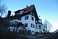
 Lage
Lage Blick über die Gmain
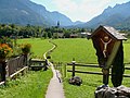 Blick nach Großgmain

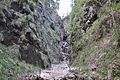 Löwenschlucht bei Schaffelpoint


