File talk:Western Bosnia 1994.png
Jump to navigation
Jump to search
References
[edit]
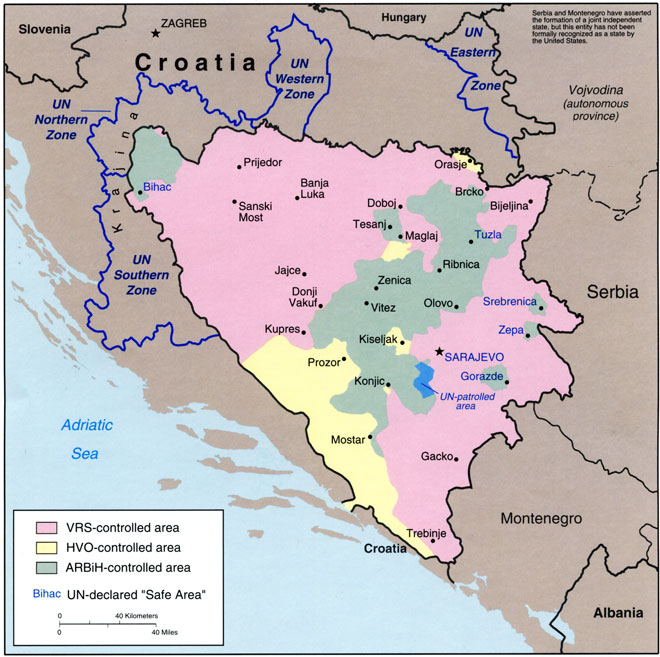
Ceha, please do not change maps which I made in contradiction with sources which I used. This is the source for the map: http://www.srpska-mreza.com/MAPS/Ethnic-groups/map-UN-1994.jpg Borders in this map are identical. If you have another source which contradicts this one then you know the solution of the problem: upload another file with another name. PANONIAN (talk) 17:54, 19 May 2015 (UTC)
- By the way, can I see the source for your claim? And also: does your source claim that these villages were under RSK control in the whole year 1994? This was the war and territories shifted from one side to another. Perhaps same situation was with these villages. PANONIAN (talk) 18:00, 19 May 2015 (UTC)
- Actually, this was indeed the case. I checked some maps which I have in computer which showing Bosnian war and different situation was on the ground in different parts of year 1994. Map which shows situation in March 1994 depicts these villages under Serbian control, but one which shows situation in August 1994 depicts them under Bosnian control. Then later they came again under Serbian control. PANONIAN (talk) 18:10, 19 May 2015 (UTC)
- Maybe, but most of the year they were under serbian control. Look;
- Actually, this was indeed the case. I checked some maps which I have in computer which showing Bosnian war and different situation was on the ground in different parts of year 1994. Map which shows situation in March 1994 depicts these villages under Serbian control, but one which shows situation in August 1994 depicts them under Bosnian control. Then later they came again under Serbian control. PANONIAN (talk) 18:10, 19 May 2015 (UTC)
- http://upload.wikimedia.org/wikipedia/commons/c/c2/Bosnia_areas_of_control_Sep_94.jpg
- http://publications.gc.ca/Collection-R/LoPBdP/images/bp374-e2.jpg
- this is from 95 http://upload.wikimedia.org/wikipedia/commons/thumb/1/12/Operation_storm_map.jpg/440px-Operation_storm_map.jpg
- So I think that those villages should be shown under serbian control...
--Čeha (talk) 22:32, 31 May 2015 (UTC)
- I already said on another discussion page that I prefer to draw maps which matching used references exactly. Redrawing it would be original research and result which we gain might not be correct. Source UN map shows front lines in one part of year 1994. In another parts of that year other front lines could be different too, not just that area near Bihać. For example, this source does not even show Western Bosnia: http://publications.gc.ca/Collection-R/LoPBdP/images/bp374-e2.jpg So, you suggest that I use Bihać front line area from there and then to guess where was front line near Velika Kladuša in that time? You can make maps too so if you want to make maps based on other sources you are free to do that. However, this map should stay as it is, since it is based on UN map and it should match UN map exactly. In fact it is better that Wikimedia have more maps which showing front line situation in different time. PANONIAN (talk) 11:51, 1 June 2015 (UTC)