File talk:Serbia1718 1739.png
Borders
[edit]
Olahus, see this:
- http://www.conflicts.rem33.com/images/Ungarn/OESTEREICH%20ENTWICKLUNG.jpg
- http://terkepek.adatbank.transindex.ro/kepek/netre/51.gif
- http://dic.academic.ru/pictures/dewiki/80/Passarowitz_1718.JPG
- http://www.remmick.org/Hubert.Hummel.Gen./Banat_pict1-.jpg
- http://www.muzejvrsac.org.rs/Istorija/Stara/Banat1776RGB.jpg
- http://www.banaterra.eu/deutsch/banat-harta1740.jpg
- http://www.wiesenhaid.de/lage/banat_1718_k.jpg
- http://upload.wikimedia.org/wikipedia/commons/8/8e/Growth_of_Habsburg_territories.jpg
- http://images.nationmaster.com/images/motw/historical/ward_1912/south_east_europe_1648.jpg
- http://www.nada.kth.se/~ovidiu/maps/images/1722-schwantz.jpg
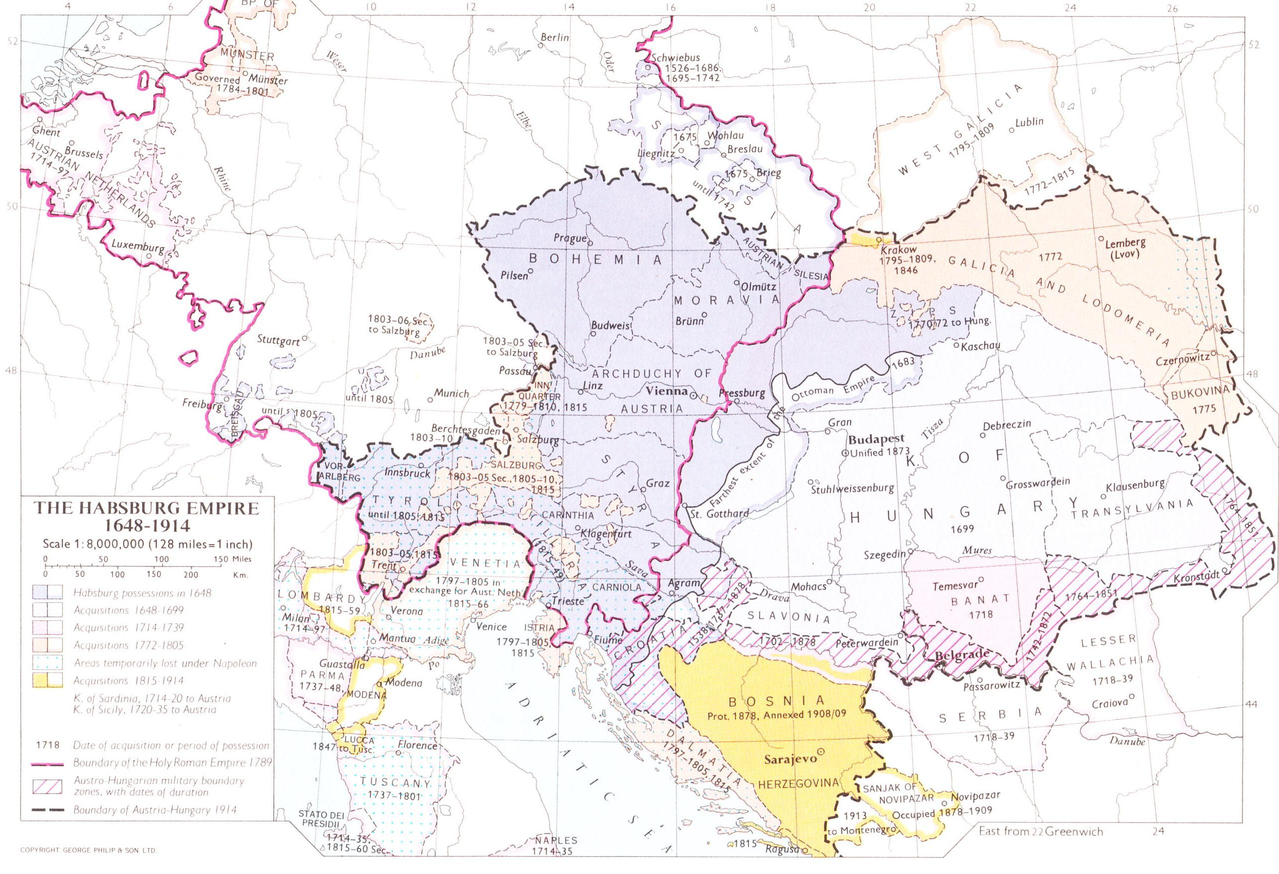
It is clear that area belonged to Serbia. I did not saw a single source that claim that eastern Serbia belonged to Banat of Temeswar. PANONIAN (talk) 13:35, 7 August 2009 (UTC)
- Well, Olahus, you are partially right - the eastern part of Serbia was indeed administered by the administration in Temescwar, but was not officially considered to be a part of the Banat of Temeswar. It was regarded as part of Serbia under separate administration and therefore all such history maps that I showed to you show this eastern area within Habsburg Serbia. PANONIAN (talk) 20:42, 7 August 2009 (UTC)
- There was no administartive division called "Serbia" in present-day Eastern Serbia. The eastern part of present-day Serbia was an integral part of the Banat of Temesvar. There was no administrative division called "Kingdom of Serbia" there. The Kingdom of Serbia ("Königreich Serbien" in this contemporary map) didn't include the districts Golubac, Kljuc, Krajina, Homolije etc. --Olahus (talk) 22:36, 8 August 2009 (UTC)
- Concerning northern Bosnia, I suppose (but I'm not sure) that it belonged completely to the Serbian Kingdom. --Olahus (talk) 22:54, 8 August 2009 (UTC)
- Ok, then tell me why all these map links that I showed to you are representing eastern Serbia within Kingdom of Serbia? How you explain that? PANONIAN (talk) 11:47, 9 August 2009 (UTC)
- Also, how you explain this: http://www.remmick.org/Hubert.Hummel.Gen./Banat_pict1-.jpg - it say that southern border of Banat in 1718 was river Danube. PANONIAN (talk) 11:49, 9 August 2009 (UTC)
- Also see this: http://www.banaterra.eu/romana/toponimii/b/banat/banat-harta1740.jpg - you can see here clear border between Banat and eastern Serbia. PANONIAN (talk) 11:51, 9 August 2009 (UTC)
- You know what, I think you are right - in fact, my sources do confirm that eastern Serbia was not administered by the Austrian administration established in Belgrade, so the reason why all these history maps show that eastern Serbia was part of Serbia in that time is probably because that area was part of Serbia in the 19th century, so the authors of these maps imposed 19th century situation into 18th century. This could be example of POV political historicism that see Serbia only in those borders from 19th century, and thus, it want to present that parts of Banat of Temeswar in the south of the Danube were Serbia, while parts in the north of the Danube (i.e. modern Serbian Banat) were not, but the truth is that both these areas were not part of Habsburg Serbia in that time, no matter of 19th century Serbian borders. Thank you for showing me my obvious mistake. PANONIAN (talk) 20:17, 9 August 2009 (UTC)
One more thing, I am not sure about exact borders of the Banat of Temeswar in the south of the Danube. I used these maps as a source for it:
- http://www.banaterra.eu/romana/toponimii/b/banat/banat-harta1740.jpg
- http://upload.wikimedia.org/wikipedia/commons/7/7c/Temeswarer_Banat.JPG
- http://www.banaterra.eu/romana/harti/banat%201740%20d.jpg
Do you have some map with more precise border line? PANONIAN (talk) 20:17, 9 August 2009 (UTC)
- Crap! I saw now this map that you posted into references: http://gettysburg.cdmhost.com/cdm4/item_viewer.php?CISOROOT=/p4016coll7&CISOPTR=429&CISOBOX=1&REC=2 - this mean that I was right first time about exact border, so I have to draw it again... PANONIAN (talk) 20:23, 9 August 2009 (UTC)
The map seems to be fine now. Only in the case of Northern Bosnia, I don't know weather it was a distinct administrative unit or part of the Serbian Kingdom. However, it was usual for the historians from the 19th century and those from the 20th century to call "Serbia" the region situated south of the Danube irrespective of the real borders. This perception occured mostly after 1833 when Serbia established it's eastern border on the Timok river and became a neighbour of Wallachia. After this time, everything that was located betweenn the Drin, the Danube and the Timok was called "Serbia" and even the historians used this term. Moreover, many maps about Serbia in the 18th, but also 19th centura are wrong and inaccurate, some are showing 1817-Serbia in the borders from 1833. Other maps are overdrawing the borders of completely different times creating just confusion. And this map was actually scanned by me (see here), but it is not very accurate (where is Northern Bosnia? Where are the borders of the administartive divisions? Did the southern border of the annexed territories strech so close to Niš ?). See here a map from 1829 (or just very few years later) that represents the Balkan Peninsula in the regions that it was perceived on that time. Serbia was perceived as a region that streched from the Daube to Sofia (today Bulgaria's capital!!!) and Pristina (but not until Prizrend), western Bosnia was called "Türk.-Croatien" (Turkish Croatia), Albania streched in the North from present-day northern Montenegro to the Ambrakian Golf (Golf von Arta) in present-day Greece. But in fact, out of the "perceived" regions in the map, only 3 existed as states: Greece (independent state), Wallachia and Serbia (both vassal states). And Serbia's borders didn't coincide with those of the region Serbia. --Olahus (talk) 18:12, 13 August 2009 (UTC)
Proposal: in the northwestern corner of the map, the text "military fronteer" should be replaced with "Principality of Syrmia" (Fürstentum Syrmien) as shown in the map. Concerning Bosnia, I would count it to the Serbian Kingdom or, if not (or maybe better), at least I would add a question mark above the text "Bosnia" as long as we don't know for sure it's administrative status in 1718-1739. --Olahus (talk) 18:22, 13 August 2009 (UTC)
- Ok, regarding Bosnia, I will try to find some data about its status and then I will change map if it indeed was part of Serbia. As for Syrmia, according to my sources, whole of Syrmia was part of Military Frontier until 1744 when county (or duchy) of Syrmia was formed in northern part of Syrmia and was included into Habsburg Kingdom of Slavonia, so I believe that description on the map regarding Syrmia is correct having in mind 1718-1739 period. PANONIAN (talk) 15:24, 16 August 2009 (UTC)
- In another words, this map does not show accurate status of Syrmia in this time, since military Frontier in this time included entire Syrmia, large parts of Bačka and even northern bank of the river Mures, see: this map and this map - the second map (despite its description that it show situation in 1718) in fact show very accurate situation in 1744. PANONIAN (talk) 15:39, 16 August 2009 (UTC)
- I checked some sources, but all of them just claim that Bosnia was under Habsburg administration with no reference whether it was part of Habsburg Kingdom of Serbia or separate political entity. Did you perhaps found some sources that can make that clear? PANONIAN (talk) 13:42, 3 September 2009 (UTC)
- In fact, the only source that I found would be this: http://www.garwood-voigt.com/catalogues/H22365SclavoniaeHomann.jpg - here is northern (or Habsburg) Bosnia shown separate from Serbia, and thus I will use this source in map references until better one is found. PANONIAN (talk) 13:55, 3 September 2009 (UTC)
- @PANONIAN: Most of the internet references do not correspond to the map, and should thus be removed as they are not references to this version (without northeastern Serbia).--Zoupan (talk) 11:49, 25 February 2016 (UTC)
- In which way they do not correspond to the map? They mostly correspond to the map in the way that they show general political situation from that time period. They might not correspond only in part which shows administrative border between Kingdom of Serbia and Banat of Temeswar, but if you examine these references better, you can conclude that they use term "Serbia" rather as a name of geographical area instead of a political unit. For example, here name "Serbia" clearly extends otside of the area controlled by Austria: http://images.nationmaster.com/images/motw/historical/ward_1912/south_east_europe_1648.jpg Or in this one, you can see also names of Bulgaria and Romania which have not politically existed in this time: https://upload.wikimedia.org/wikipedia/commons/8/8e/Growth_of_Habsburg_territories.jpg (it imply that Serbia, Bulgaria and Romania are rather depicted as geographical areas there). PANONIAN (talk) 06:13, 29 February 2016 (UTC)