File talk:Pagania9st.png
Jump to navigation
Jump to search
Map changes
[edit]
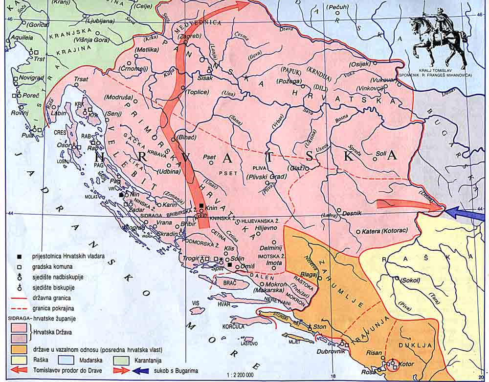
Now, Ceha, you claim that you made this map version as one which shows data from Croatian sources, but it was quite different from this Croatian source: http://www.croatia-in-english.com/images/maps/800s.jpg I now modified this map to match Croatian source more exactly. These are changes:
- Land border of Pagania in Croatian source is bigger
- Border of Zachlumia in Croatian source is different than one in Serbian source (you simply kept Zachlumia border from Serbian atlas in this map version, which does not match Croatian source)
- Dubrovnik area is bigger in Croatian source than in Serbian
- Some islands are in Croatian source depicted as parts of Croatia instead of Byzantine Empire
- Mljet was part of Pagania in the 9th century, according to Croatian source. It is only in the map which shows 10th century that Mljet is depicted as part of Zachlumia: http://www.croatia-in-english.com/images/maps/tomislav.jpg PANONIAN (talk) 10:07, 14 May 2015 (UTC)
- The border of Neretva and Hum is taken from ; http://oi59.tinypic.com/i3w1ab.jpg
- For Mljet, ok. --Čeha (talk) 11:49, 15 May 2015 (UTC)
- Wtf? Are you kidding me? This is map which you made and it does not even show Pagania or medieval borders but Croatian dialects in Croatia and BIH: http://oi59.tinypic.com/i3w1ab.jpg Can you be serious and try to explain yourself? This map version which you uploaded is completelly unsourced. I am not going to revert you because you are original uploader of this file, but if you do not show real source for borders in this map (if there is such source, anyway), I will be forced to remove it from Wikipedia articles since there is no source which support it. When I said that in wikimedia there should be maps which showing both, Serbian and Croatian view, I meant the "view of mainstream Serbian or Croatian historical science". Original research conducted by wikimedia users does not fit into this description. PANONIAN (talk) 14:09, 15 May 2015 (UTC)
- Mea culpa, wrong map. http://free-zg.t-com.hr/Andelko/Slike/DAIzupanije.jpg is the map which show croatian parish Imota which goes to Neretva... That is the main difference between maps.--Čeha (talk) 19:38, 15 May 2015 (UTC)
- All right. However, what kind of reference is that: http://free-zg.t-com.hr/Andelko/Slike/DAIzupanije.jpg Who is this uploader Anđelko? This map looks like original research of some kid, not as serious academic reference. Look main user page of this person: http://free-zg.t-com.hr/Andelko/ He simply painted lines on topographic maps. Do you have any serious reference which show same border in Imota area? PANONIAN (talk) 20:02, 15 May 2015 (UTC)
- Hm, I thought he wrote a book about it. This is http://free-zg.t-com.hr/Andelko/ for certain not map from 9.century. I made some modifications on the map. As I wrote earlier the border of Imota parish is basicly shown in Croatian kings, which qoute this map http://cro-eu.com/galerija-fotografija/albums/userpics/10001/Sl_%201_%20Liburnija%20i%20Dalmacija%20u%20doba%20Borne.jpg ... --Čeha (talk) 00:10, 17 May 2015 (UTC)
- All right. However, what kind of reference is that: http://free-zg.t-com.hr/Andelko/Slike/DAIzupanije.jpg Who is this uploader Anđelko? This map looks like original research of some kid, not as serious academic reference. Look main user page of this person: http://free-zg.t-com.hr/Andelko/ He simply painted lines on topographic maps. Do you have any serious reference which show same border in Imota area? PANONIAN (talk) 20:02, 15 May 2015 (UTC)
- Mea culpa, wrong map. http://free-zg.t-com.hr/Andelko/Slike/DAIzupanije.jpg is the map which show croatian parish Imota which goes to Neretva... That is the main difference between maps.--Čeha (talk) 19:38, 15 May 2015 (UTC)
- Wtf? Are you kidding me? This is map which you made and it does not even show Pagania or medieval borders but Croatian dialects in Croatia and BIH: http://oi59.tinypic.com/i3w1ab.jpg Can you be serious and try to explain yourself? This map version which you uploaded is completelly unsourced. I am not going to revert you because you are original uploader of this file, but if you do not show real source for borders in this map (if there is such source, anyway), I will be forced to remove it from Wikipedia articles since there is no source which support it. When I said that in wikimedia there should be maps which showing both, Serbian and Croatian view, I meant the "view of mainstream Serbian or Croatian historical science". Original research conducted by wikimedia users does not fit into this description. PANONIAN (talk) 14:09, 15 May 2015 (UTC)