File:Zugbeeinflussungssysteme Deutschland Karte.svg
Jump to navigation
Jump to search

Size of this PNG preview of this SVG file: 443 × 600 pixels. Other resolutions: 177 × 240 pixels | 355 × 480 pixels | 567 × 768 pixels | 756 × 1,024 pixels | 1,513 × 2,048 pixels | 512 × 693 pixels.
Original file (SVG file, nominally 512 × 693 pixels, file size: 982 KB)
Captions
Captions
Add a one-line explanation of what this file represents
Summary[edit]
| Description |
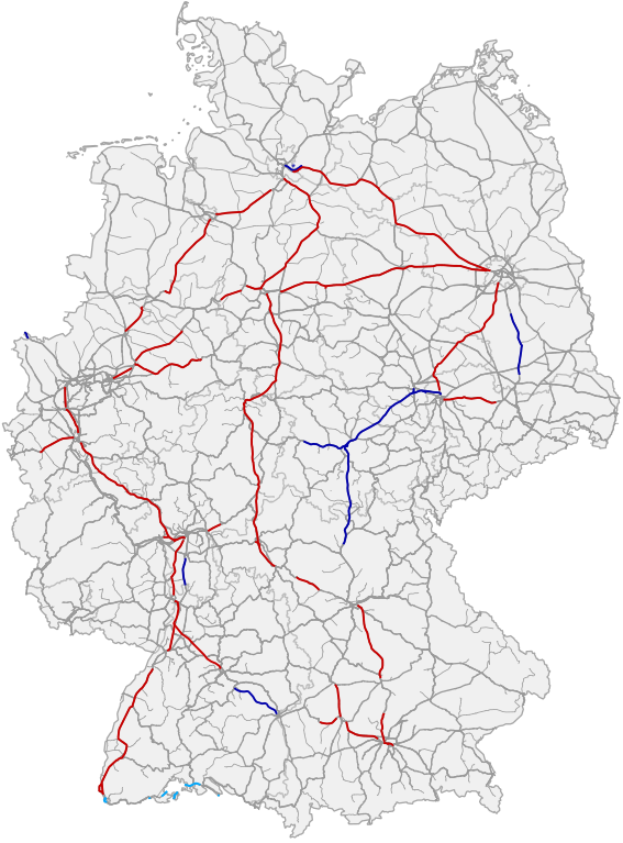
Deutsch: Karte der Zugbeeinflussungssysteme in Deutschland. Rot = Linienförmige Zugbeeinflussung, dunkelblau = ETCS Level 2 Full Supervision, hellblau ETCS Level 1 Limited Supervision. Bei den mit einem Stern (*) gekennzeichneten Strecken handelt es sich um reine S-Bahn-Strecken. Datenquelle: OpenStreetMap, DB ISR, Oktober 2022.
English: Map of train control / cab signalling systems in Germany. Red = Linienförmige Zugbeeinflussung, dark blue = ETCS level 2 full supervision, light blue = ETCS level 1 limited supervision. Sections labeled with an asterisk (*) are light rail lines. Data source: OpenStreetMap, DB ISR, October 2022.
LZB ETCS Level 1 limited supervision ETCS Level 2 full supervision |
| Date | |
| Source | Own work, using OpenStreetMap data |
| Author | Hbf878, OpenStreetMap contributors |
Licensing[edit]
| Description |
This map was created from OpenStreetMap project data, collected by the community. This map may be incomplete, and may contain errors. Don't rely solely on it for navigation. |
|||
| Date | (see file history) | |||
| Source | openstreetmap.org | |||
| Creator |
OpenStreetMap contributors |
|||
| Permission (Reusing this file) |
OpenStreetMap data is available under the Open Database License (details). Map tiles are licensed under the Creative Commons Attribution-ShareAlike 2.0 license (CC-BY-SA 2.0).
This file is licensed under the Creative Commons Attribution-Share Alike 2.0 Generic license.
|
|||
| Georeferencing | If inappropriate please set warp_status = skip to hide. |
File history
Click on a date/time to view the file as it appeared at that time.
| Date/Time | Thumbnail | Dimensions | User | Comment | |
|---|---|---|---|---|---|
| current | 23:09, 18 December 2022 | | 512 × 693 (982 KB) | Hbf878 (talk | contribs) | Wendlingen-Ulm, Darmstadt |
| 21:18, 14 October 2022 |  | 512 × 693 (980 KB) | Hbf878 (talk | contribs) | K | |
| 18:58, 29 September 2022 |  | 512 × 693 (980 KB) | IGEL (talk | contribs) | Neue Farbe fuer LS | |
| 18:48, 29 September 2022 |  | 512 × 693 (980 KB) | IGEL (talk | contribs) | ETCS L1 LS mit eigener Farbe. Auf der Strecke 2600 (Aachen-Grenze) gibt es noch kein ETCS, siehe https://fragdenstaat.de/anfrage/etcs-ausbaustatus-raum-aachen-1/692418/anhang/Anlage1-Projektsteckbrief.pdf. Auch OSM zeigt (inzwischen?) ETCS nur in Belgien. | |
| 17:53, 14 November 2021 |  | 512 × 693 (980 KB) | Hbf878 (talk | contribs) | update 20/2021 | |
| 14:31, 1 December 2020 |  | 512 × 693 (976 KB) | Hbf878 (talk | contribs) | update 12/2020 | |
| 16:07, 6 May 2020 |  | 762 × 1,031 (4.06 MB) | Hbf878 (talk | contribs) | shading3 | |
| 14:37, 6 May 2020 |  | 762 × 1,031 (4.06 MB) | Hbf878 (talk | contribs) | shading2 | |
| 14:18, 6 May 2020 |  | 762 × 1,031 (4.06 MB) | Hbf878 (talk | contribs) | correction | |
| 13:16, 6 May 2020 |  | 762 × 1,031 (4.06 MB) | Hbf878 (talk | contribs) | shading |
You cannot overwrite this file.
File usage on Commons
The following 13 pages use this file:
- User:Chumwa/OgreBot/Public transport information/2020 December 1-10
- User:Chumwa/OgreBot/Public transport information/2020 May 1-10
- User:Chumwa/OgreBot/Public transport information/2021 November 11-20
- User:Chumwa/OgreBot/Public transport information/2022 December 11-20
- User:Chumwa/OgreBot/Public transport information/2022 October 11-20
- User:Chumwa/OgreBot/Public transport information/2022 September 21-30
- User:Chumwa/OgreBot/Transport Maps/2020 December 1-10
- User:Chumwa/OgreBot/Transport Maps/2020 May 1-10
- User:Chumwa/OgreBot/Transport Maps/2021 November 11-20
- User:Chumwa/OgreBot/Transport Maps/2022 December 11-20
- User:Chumwa/OgreBot/Transport Maps/2022 October 11-20
- User:Chumwa/OgreBot/Transport Maps/2022 September 21-30
- File:Zugbeeinflussungssysteme in Deutschland, April 2018.png
File usage on other wikis
The following other wikis use this file:
- Usage on de.wikipedia.org
- Usage on en.wikipedia.org