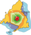
File:Zonas Abono Transportes Madrid.svg
From Wikimedia Commons, the free media repository
Jump to navigation
Jump to search

Size of this PNG preview of this SVG file: 531 × 600 pixels. Other resolutions: 212 × 240 pixels | 425 × 480 pixels | 680 × 768 pixels | 907 × 1,024 pixels | 1,813 × 2,048 pixels.
Original file (SVG file, nominally 680 × 768 pixels, file size: 346 KB)
File information
Structured data
Captions
Captions
Add a one-line explanation of what this file represents
Summary[edit]
| DescriptionZonas Abono Transportes Madrid.svg | Este mapa no debe ser usado para cálculos detallados al no representar milimétricamente la geografía de Madrid. | |||
| Date | 3 August 2006 (original upload date) | |||
| Source | No machine-readable source provided. Own work assumed (based on copyright claims). | |||
| Author | No machine-readable author provided. Benedicto16 assumed (based on copyright claims). | |||
| SVG development InfoField | This bad Adobe SVG map is very large because Benedicto16 kept the superfluous Adobe PGF or other CDATA garbage .
|
Licensing[edit]
| Public domainPublic domainfalsefalse |
| I, the copyright holder of this work, release this work into the public domain. This applies worldwide. In some countries this may not be legally possible; if so: I grant anyone the right to use this work for any purpose, without any conditions, unless such conditions are required by law. |
File history
Click on a date/time to view the file as it appeared at that time.
| Date/Time | Thumbnail | Dimensions | User | Comment | |
|---|---|---|---|---|---|
| current | 11:04, 10 September 2023 |  | 680 × 768 (346 KB) | PatriaDeTodos (talk | contribs) | El municipio segoviano del Real Sitio de San Ildefonso -La Granja- está incluido en la línea C-9 de cercanías, en la zona C2 |
| 16:46, 25 February 2008 |  | 372 × 420 (1.03 MB) | Javitomad (talk | contribs) | Añado "Madrid" escrito. | |
| 10:39, 3 August 2006 |  | 372 × 420 (1.02 MB) | Benedicto16 (talk | contribs) | ||
| 10:33, 3 August 2006 |  | 1,486 × 1,677 (960 KB) | Benedicto16 (talk | contribs) | ||
| 10:23, 3 August 2006 |  | 1,486 × 1,677 (145 KB) | Benedicto16 (talk | contribs) | Este mapa no debe ser usado para cálculos detallados al no representar milimétricamente la geografía de Madrid. |
You cannot overwrite this file.
File usage on Commons
The following 5 pages use this file:
File usage on other wikis
The following other wikis use this file:
- Usage on ast.wikipedia.org
- Usage on en.wikipedia.org
- Usage on eo.wikipedia.org
- Usage on es.wikipedia.org
- Usage on fr.wikipedia.org
- Usage on ga.wikipedia.org
- Usage on he.wikipedia.org
- Usage on it.wikipedia.org
- Usage on ja.wikipedia.org
- Usage on kk.wikipedia.org
- Usage on pl.wikipedia.org
- Usage on pt.wikipedia.org
- Usage on ru.wikipedia.org
- Usage on sk.wikipedia.org
- Usage on www.wikidata.org
- Usage on zh.wikipedia.org
Metadata
This file contains additional information such as Exif metadata which may have been added by the digital camera, scanner, or software program used to create or digitize it. If the file has been modified from its original state, some details such as the timestamp may not fully reflect those of the original file. The timestamp is only as accurate as the clock in the camera, and it may be completely wrong.
| Width | 680 |
|---|---|
| Height | 768 |
Hidden categories:
