File:Zona rossa Vesuvio.png
Jump to navigation
Jump to search
Size of this preview: 711 × 599 pixels. Other resolutions: 285 × 240 pixels | 570 × 480 pixels | 942 × 794 pixels.
Original file (942 × 794 pixels, file size: 904 KB, MIME type: image/png)
Captions
Captions
Add a one-line explanation of what this file represents
Summary
[edit]| Description |
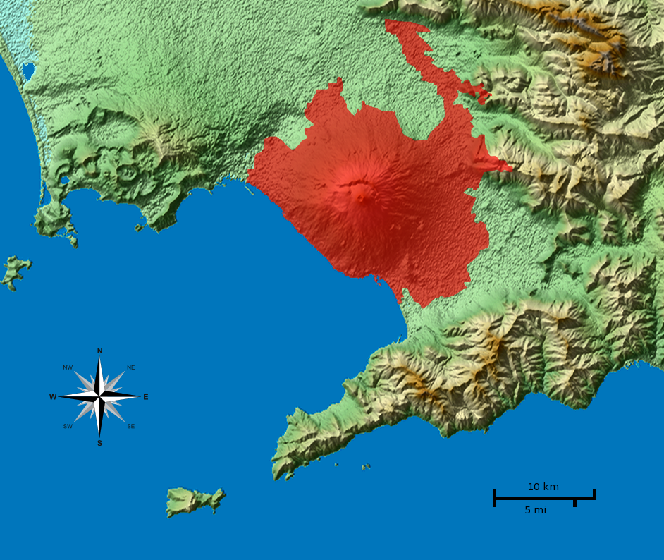
English: Shaded terrain map of the Naples and Mount Vesuvius region from SRTM3 elevation data. Each pixel corresponds to about 70x70 m. SRTM tile used was http://dds.cr.usgs.gov/srtm/version2_1/SRTM3/Eurasia/N40E014.hgt.zip. The top of the image is 41°N, the left side is 14°E. In red is marked the "Red Zone" of Vesuvius. |
||
| Date | |||
| Source | from the file of Morn the Gorn and the file [1] | ||
| Author | Gigillo83, from the original of Morn the Gorn | ||
| Other versions |
Derivative works of this file: Vesuvius SRTM3.png LicenzaI, the copyright holder of this work, hereby publish it under the following licenses: This file is licensed under the Creative Commons Attribution-Share Alike 3.0 Unported license.
You may select the license of your choice. |

![[1]](http://www.vesuvius.it/wp-content/uploads/2011/03/zona-rossa-vesuvio-610x419.jpg)
File history
Click on a date/time to view the file as it appeared at that time.
| Date/Time | Thumbnail | Dimensions | User | Comment | |
|---|---|---|---|---|---|
| current | 10:47, 28 April 2013 | | 942 × 794 (904 KB) | Fulvio314 (talk | contribs) | More precise borders |
| 18:06, 21 April 2013 |  | 942 × 794 (1.01 MB) | Fulvio314 (talk | contribs) | Extended to new included zones | |
| 15:04, 20 June 2011 |  | 942 × 794 (1.01 MB) | Gigillo83 (talk | contribs) | + names | |
| 14:22, 20 June 2011 |  | 942 × 794 (1 MB) | Gigillo83 (talk | contribs) | == Summary == {{Information |Description={{en|1=Shaded terrain map of the Naples and Mount Vesuvius region from SRTM3 elevation data. Each pixel corresponds to about 70x70 m. SRTM tile used was http://dds.cr.usgs.gov/srtm/version2_1/SRTM3/Eur |
You cannot overwrite this file.
File usage on Commons
The following page uses this file:
File usage on other wikis
The following other wikis use this file:
- Usage on cs.wikipedia.org
- Usage on it.wikipedia.org
- Usage on pt.wikipedia.org
Metadata
Categories:
- Hazard maps of Mount Vesuvius
- Maps of the Gulf of Naples
- Maps of Campi Flegrei
- Maps of Procida
- Maps of Naples
- Maps of Sorrento
- Maps of Capri
- Hazard maps of volcanoes
- Volcano monitoring in Italy
- Topographic maps of volcanoes in Italy
- Volcanic disaster prevention in Italy
- Volcanological maps of Mount Vesuvius
- 2011 in volcanology