File:Zeitreihe der Lufttemperatur in Deutschland.png
Jump to navigation
Jump to search

Size of this preview: 800 × 400 pixels. Other resolutions: 320 × 160 pixels | 640 × 320 pixels | 1,024 × 512 pixels | 1,280 × 640 pixels | 2,560 × 1,280 pixels | 24,000 × 12,000 pixels.
Original file (24,000 × 12,000 pixels, file size: 5.56 MB, MIME type: image/png)
Captions
Captions
Add a one-line explanation of what this file represents
Summary[edit]
| Warning | The original file is very high-resolution. It might not load properly or could cause your browser to freeze when opened at full size. |
|---|
| Description |
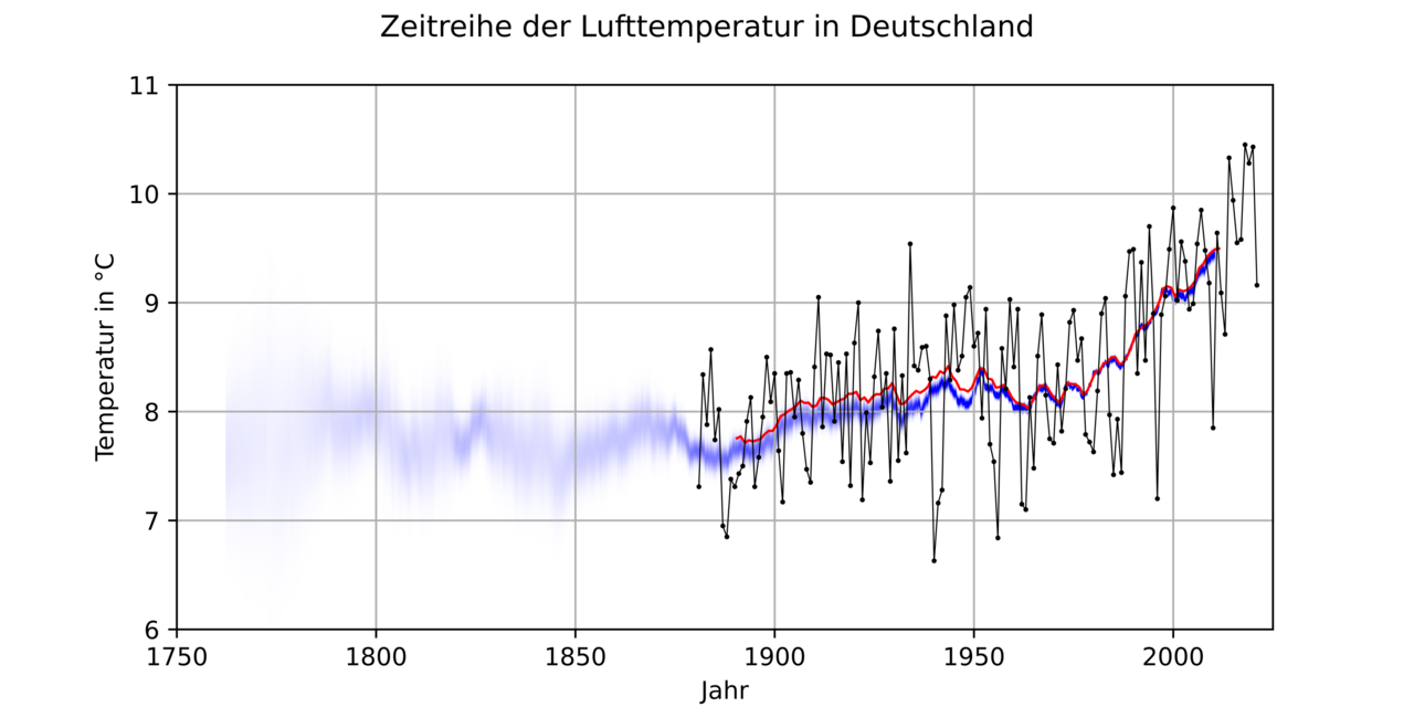
Deutsch: Darstellung der regelmäßig aktualisierten Zeitreihen der Luftemperaturen in Deutschland der Berkeley Earth Surface Temperature (Berkeley) und des Deutschen Wetterdienstes (DWD). Die Zeitreihe des DWD wird durch Kreise, die die offiziellen Jahremitteltemperaturen repräsentieren, und eine rote 20-Jahres Mittelwertslinie dargestellt. Bei der Berkeley-Zeitreihe wird aufgrund der großen Unsicherheit der historischen Werte nur der blaue 20-Jahres-Mittelwert sowie seine Unsicherheit für die Anomalie zur CLINO 1951 bis 1980 als Gausscher Weichzeichner in y-Achsenrichtung (das angegeben 95 %-Konfidenzintervall wird als zweifache Standardabweichung interpretiert) dargestellt. Dabei wird nicht beachtet, dass die Berkeley-Mitteltemperatur dieser CLINO mit 8,11+/-0,17°C nur ungenau bestimmt ist und 0,03°C niedriger ist als die der DWD-Zeitreihe. |
||
| Date | |||
| Source |
https://opendata.dwd.de/climate_environment/CDC/regional_averages_DE/annual/air_temperature_mean/regional_averages_tm_year.txt In: DWD Climate Data Center (CDC): Jährliche Gebietsmittel der Lufttemperatur (Jahresmittel) in °C (2 m Höhe), Version v19.3. 3. Januar 2022, abgerufen am 3. Januar 2022. http://berkeleyearth.lbl.gov/auto/Regional/TAVG/Text/germany-TAVG-Trend.txt Germany. In: berkeleyearth.lbl.gov. 13. Januar 2021, abgerufen am 2. Januar 2022. |
||
| Author | Habitator terrae; Datenbasis: Deutscher Wetterdienst, Einzelwerte zusätzlich gemittelt und Daten von Berkeley Earth (http://www.berkeleyearth.org) ergänzt | ||
| Permission (Reusing this file) |
und |
File history
Click on a date/time to view the file as it appeared at that time.
| Date/Time | Thumbnail | Dimensions | User | Comment | |
|---|---|---|---|---|---|
| current | 16:17, 2 January 2022 | | 24,000 × 12,000 (5.56 MB) | Habitator terrae (talk | contribs) | Uploaded a work by Habitator terrae; Datenbasis: Deutscher Wetterdienst, Einzelwerte zusätzlich gemittelt und Daten von Berkeley Earth (http://www.berkeleyearth.org) ergänzt from https://opendata.dwd.de/climate_environment/CDC/regional_averages_DE/annual/air_temperature_mean/regional_averages_tm_year.txt In: DWD Climate Data Center (CDC): ''Jährliche Gebietsmittel der Lufttemperatur (Jahresmittel) in °C (2 m Höhe), Version v19.3''. 2. Dezember 2021, abgerufen am 2. Januar 2022. Zusätzlich vor... |
You cannot overwrite this file.
File usage on Commons
The following page uses this file: