File:Zeichen 391 - Mautpflichtige Strecke, StVO 2003.svg
Jump to navigation
Jump to search

Size of this PNG preview of this SVG file: 600 × 600 pixels. Other resolutions: 240 × 240 pixels | 480 × 480 pixels | 768 × 768 pixels | 1,024 × 1,024 pixels | 2,048 × 2,048 pixels | 601 × 601 pixels.
Original file (SVG file, nominally 601 × 601 pixels, file size: 14 KB)
Captions
Captions
Add a one-line explanation of what this file represents
Summary[edit]
| Description |
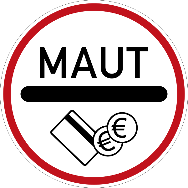
Deutsch: Zeichen 391 – Mautpflichtige Strecke, StVO 2003. Farblich korrekte Umsetzung der Originalvorlage mit dem digitalen RAL-Farbton „Verkehrsrot“. Im Verkehrsblatt, Heft 24, 1976, Seite 786, wird das Zeichen „Zollstelle“, aus dem Zeichen 391 abgeleitet wurde, in seinen Details abgebildet. Die Gesamtgröße beträgt in der Regel 600 x 600 mm, in Ausnahmefälle ist eine andere Größe möglich. Die Lichtkantenbreite beträgt 10 mm, der rote Rahmen ist 24 mm breit. Die Versalhöhe beträgt bei Zeichen 391 insgesamt 100 mm. Der Ausrundungshalbmesser am linken und rechten Ende des schwarzen Balkens beträgt 50 mm.
English: Sign No. 391 – toll road, introduced 2003 |
| Date | |
| Source | Straßenverkehrs-Ordnung, DIN-Normen, RAL-Farbkarte und Verkehrsblatt |
| Author | Andreas 06, korrekte Umsetzung 2017 durch: Mediatus |
| SVG development |
|
|
Do not upload new revisions over this file version without my explicit consent. Instead, use the possibility to upload a new version under a new name and tag it as a derivative or extract of this file. Mediatus |

Licensing[edit]
| This image is in the public domain according to German copyright law because it is part of a statute, ordinance, official decree or judgment (official work) issued by a German authority or court (§ 5 Abs.1 UrhG).
|
 |
| This road sign image is in the public domain according to German copyright law because it is part of the German Verkehrszeichenkatalog (Road Sign Catalogue), Straßenverkehrsordnung (Road Traffic Code) or other statues, ordinances or official decrees proclaimed in the Verkehrsblatt (Traffic Gazette) (§ 5 Abs. 1 UrhG).
|
 |
File history
Click on a date/time to view the file as it appeared at that time.
| Date/Time | Thumbnail | Dimensions | User | Comment | |
|---|---|---|---|---|---|
| current | 15:09, 21 October 2017 | | 601 × 601 (14 KB) | Mediatus (talk | contribs) | korrekte Umsetzung |
| 09:30, 8 April 2016 |  | 703 × 703 (19 KB) | Mediatus (talk | contribs) | neue, korrekte Datei | |
| 21:45, 10 February 2014 |  | 725 × 725 (9 KB) | Mediatus (talk | contribs) | korrekter digitaler RAL-Farbton Verkehrsrot (Farbcode: #C1121C) | |
| 15:31, 29 July 2006 |  | 725 × 725 (7 KB) | Andreas 06 (talk | contribs) | {{German}} Zeichen 391 – Mautpflicht <br />{{English}} Sign No. 391 – toll road Image taken from the website of the Bundesamt for Straßenverkehr (Federal Office for Road Traffic), not copyrighted because it is part of the [[:de:Straßenverkehrsordnu |
You cannot overwrite this file.
File usage on Commons
The following 7 pages use this file:
File usage on other wikis
The following other wikis use this file:
- Usage on ar.wikipedia.org
- Usage on bg.wikipedia.org
- Usage on bs.wikipedia.org
- Usage on cs.wikipedia.org
- Usage on da.wikipedia.org
- Usage on de.wikipedia.org
- Tauern Autobahn
- Bundesstraße 104
- Bundesstraße 105
- Felbertauern Straße
- Mautstelle
- Bundesstraße 75
- Roßfeldhöhenringstraße
- Autostrada A4 (Polen)
- Pyhrn Autobahn
- Karawanken Autobahn
- M1 motorway (Irland)
- Arlberg Schnellstraße
- Großglockner-Hochalpenstraße
- Otoyol 31
- Otoyol 4
- Otoyol 32
- Otoyol 52
- Otoyol 2
- Silvrettastraße
- Liste der Tunnel auf den Färöern
- Attiki Odos
- Benutzer Diskussion:Qualle/Archiv1
- Bildtafel der Verkehrszeichen in der Bundesrepublik Deutschland von 2013 bis 2017
- Autoroute A 7
- M6 Toll motorway
- Autoroute A 40
- Autoroute A404
- Autostrada A1 (Polen)
- Autostrada A2 (Polen)
- Autostrada A22
View more global usage of this file.
Metadata
Categories:
- Zeichen 391
- SVG prohibitory road signs of Germany
- Diagrams of round road signs of Germany
- Diagrams of historic road signs of Germany, 2003 set
- Diagrams of information road signs of Germany, 2013 set
- Diagrams of information road signs of Germany, 2017 set
- Toll station (road sign)
- Diagrams of German-language road signs