File:Zanesfield-ohio-limits.jpg
Jump to navigation
Jump to search

Size of this preview: 800 × 282 pixels. Other resolutions: 320 × 113 pixels | 640 × 225 pixels | 1,024 × 361 pixels | 1,280 × 451 pixels | 3,000 × 1,057 pixels.
Original file (3,000 × 1,057 pixels, file size: 827 KB, MIME type: image/jpeg)
Captions
Captions
Add a one-line explanation of what this file represents
Summary[edit]
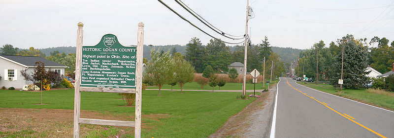
City limits of Zanesfield, Ohio.
Photo shot by Derek Jensen (Tysto), 2005-October-06
The plaque says:
- HISTORIC LOGAN COUNTY
- Highest point in Ohio. Site of:
- Ten Indian towns; Wapatomica,
- Blue Jacket, Mackachak, Maluntha,
- Lewis, Old, Zane, Solomon, McKee
- and Buckongehelas.
- Zane-Kenton Monument: Squaw Rock;
- Fort Wapatomica; Kenton's Grave.
- Here first organized Methodist Church
- Mission movement began, 1819.
Licensing[edit]
| I, the copyright holder of this work, release this work into the public domain. This applies worldwide. In some countries this may not be legally possible; if so: I grant anyone the right to use this work for any purpose, without any conditions, unless such conditions are required by law. |
File history
Click on a date/time to view the file as it appeared at that time.
| Date/Time | Thumbnail | Dimensions | User | Comment | |
|---|---|---|---|---|---|
| current | 19:51, 7 October 2005 | 3,000 × 1,057 (827 KB) | Tysto (talk | contribs) | City limits of Zanesfield, Ohio.<br> Photo shot by Derek Jensen (Tysto), 2005-October-06 The plaque says:<br> :''HISTORIC LOGAN COUNTY''<br> :''Highest point in Ohio. Site of:''<br> :''Ten Indian towns; Wapatomica,'' |
You cannot overwrite this file.
File usage on Commons
There are no pages that use this file.
File usage on other wikis
The following other wikis use this file:
- Usage on de.wikipedia.org
- Usage on en.wikipedia.org
- Usage on ja.wikipedia.org